IMAGES TAKEN NEAR TO
Homersfield, HARLESTON, IP20 0NS
Introduction
This page details the photographs taken nearby to IP20 0NS by members of the Geograph project.
The Geograph project started in 2005 with the aim of publishing, organising and preserving representative images for every square kilometre of Great Britain, Ireland and the Isle of Man.

There are currently over 7.5m images from over14,400 individuals and you can help contribute to the project by visiting https://www.geograph.org.uk
Image Map
Images are licensed for reuse under creativecommons.org/licenses/by-sa/2.0
Notes
- Clicking on the map will re-center to the selected point.
- The higher the marker number, the further away the image location is from the centre of the postcode.
Image Listing (14 Images Found)
Images are licensed for reuse under creativecommons.org/licenses/by-sa/2.0
Image
Details
Distance
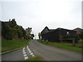
1

View towards Valley Farm from Mendham Lane
Image: © Evelyn Simak
Taken: 24 Mar 2014
0.01 miles
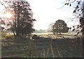
4
Frost in the early morning sun
looking across the marshes which form part of the Waveney Valley at Homersfield in November
Image: © Adrian S Pye
Taken: 17 Nov 2007
0.11 miles
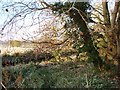
5

Alder over the Waveney
The morning sun illuminates hedgerows beyond the northern bank of the Waveney, near Homersfield. Taken at around 7.25.
Image: © Hugh Chevallier
Taken: 27 Feb 2015
0.11 miles


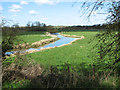
8
Past The Gate
View of the River Waveney past the gate near to Homersfield, Suffolk.
Image: © Keith Evans
Taken: 6 May 2007
0.12 miles
9
Frosty morning in the Waveney Valley
Looking over marshland towards the river Waveney in the middle distance on a frosty November morning.
Image: © Adrian S Pye
Taken: 17 Nov 2007
0.16 miles
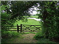
10
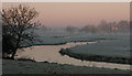
The River Waveney near Homersfield
The river is the county boundary for many miles hereabouts. The foreground and the bank to the left is Suffolk; to the right is Norfolk. Limbourne Mill (Norfolk) is in the distance.
Image: © Hugh Chevallier
Taken: 8 Mar 2011
0.19 miles