IMAGES TAKEN NEAR TO
The Common, HARLESTON, IP20 0LP
Introduction
This page details the photographs taken nearby to The Common, IP20 0LP by members of the Geograph project.
The Geograph project started in 2005 with the aim of publishing, organising and preserving representative images for every square kilometre of Great Britain, Ireland and the Isle of Man.

There are currently over 7.5m images from over14,400 individuals and you can help contribute to the project by visiting https://www.geograph.org.uk
Image Map
Images are licensed for reuse under creativecommons.org/licenses/by-sa/2.0
Notes
- Clicking on the map will re-center to the selected point.
- The higher the marker number, the further away the image location is from the centre of the postcode.
Image Listing (32 Images Found)
Images are licensed for reuse under creativecommons.org/licenses/by-sa/2.0
Image
Details
Distance
1
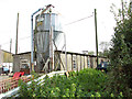
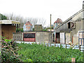
Prefabricated concrete building on Fir Tree Farm
This is building No. 260a, one of the six BFC huts remaining on the former Site 4 of RAF Metfield, which was an active airfield during WW2.
Image: © Evelyn Simak
Taken: 22 Oct 2014
0.01 miles
2
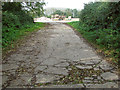
Concreted road through Metfield Common
This road dates from WW2 when RAF Metfield was an active airfield. At that time the road lead through Communal Site 1. Today it is a public footpath.
Image: © Evelyn Simak
Taken: 22 Oct 2014
0.04 miles
4
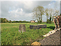
View towards Fir Tree Farm
The low long building (building no. 260b) seen in the centre is one of the six BFC huts remaining on the former Site 4 of RAF Metfield, which was an active airfield during WW2.
Image: © Evelyn Simak
Taken: 22 Oct 2014
0.06 miles
5
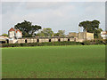
Buildings at Fir Tree Farm
The small building (no. 260b) seen at the centre is one of the six BFC huts remaining on the former Site 4 of RAF Metfield, which was an active airfield during WW2.
Image: © Evelyn Simak
Taken: 22 Oct 2014
0.06 miles
6
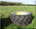
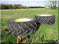
Tractor tyre on Metfield Common
The locations of the two WW2 WAAF sites of RAF Metfield can be seen in the background: the wood at left marks the location of the WAAF Site 1 and the hedge to the right with a crane peeking over it was the WAAF Site 2.
Image: © Evelyn Simak
Taken: 22 Oct 2014
0.07 miles
7
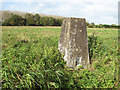
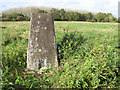
Triangulation pillar on Metfield Common
Image: © Evelyn Simak
Taken: 22 Oct 2014
0.07 miles
8
Triangulation pillar on Metfield Common
Image: © Evelyn Simak
Taken: 22 Oct 2014
0.08 miles
9
Triangulation pillar on Metfield Common
The wood seen in the background marks the location of one of the two WAAF sites of RAF Metfield when it was an active airfield in WW2.
Image: © Evelyn Simak
Taken: 22 Oct 2014
0.08 miles
10
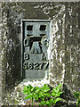
Triangulation pillar on Metfield Common (plaque)
For a full view of the trig pillar see > http://www.geograph.org.uk/photo/4214740.
Image: © Evelyn Simak
Taken: 22 Oct 2014
0.08 miles