IMAGES TAKEN NEAR TO
Mendham, HARLESTON, IP20 0JH
Introduction
This page details the photographs taken nearby to IP20 0JH by members of the Geograph project.
The Geograph project started in 2005 with the aim of publishing, organising and preserving representative images for every square kilometre of Great Britain, Ireland and the Isle of Man.

There are currently over 7.5m images from over14,400 individuals and you can help contribute to the project by visiting https://www.geograph.org.uk
Image Map
Images are licensed for reuse under creativecommons.org/licenses/by-sa/2.0
Notes
- Clicking on the map will re-center to the selected point.
- The higher the marker number, the further away the image location is from the centre of the postcode.
Image Listing (23 Images Found)
Images are licensed for reuse under creativecommons.org/licenses/by-sa/2.0
Image
Details
Distance
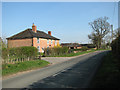
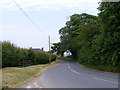
2
Withersdale Street
Looking west along the B1123 into Withersdale Street near to Harleston.
Image: © Keith Evans
Taken: 9 Sep 2007
0.02 miles
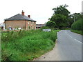
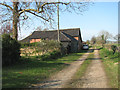
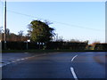
6
B1123 Withersdale Road
Looking towards Priory Farm at the junction with Mill Lane
Image: © Geographer
Taken: 18 Jun 2013
0.05 miles
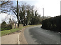
7
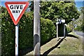
Withersdale Street: The junction of Withersdale Road and Mill Lane
Image: © Michael Garlick
Taken: 24 Apr 2020
0.07 miles
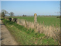
8
Footpath to the site of St Mary's Priory
Image: © Evelyn Simak
Taken: 29 Mar 2014
0.07 miles
9
B1123 The Street, Withersdale road junction
Image: © Geographer
Taken: 22 Dec 2011
0.07 miles
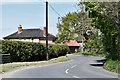
10
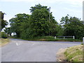
Mill Lane
At the junction with the B1123 Whithersdale Road
Image: © Geographer
Taken: 18 Jun 2013
0.08 miles