IMAGES TAKEN NEAR TO
Wortwell, HARLESTON, IP20 0EJ
Introduction
This page details the photographs taken nearby to IP20 0EJ by members of the Geograph project.
The Geograph project started in 2005 with the aim of publishing, organising and preserving representative images for every square kilometre of Great Britain, Ireland and the Isle of Man.

There are currently over 7.5m images from over14,400 individuals and you can help contribute to the project by visiting https://www.geograph.org.uk
Image Map
Images are licensed for reuse under creativecommons.org/licenses/by-sa/2.0
Notes
- Clicking on the map will re-center to the selected point.
- The higher the marker number, the further away the image location is from the centre of the postcode.
Image Listing (3 Images Found)
Images are licensed for reuse under creativecommons.org/licenses/by-sa/2.0
Image
Details
Distance
1
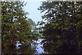
Yew Tree Lake, Waveney Valley Lakes
The lakes at Waveney Valley were first excavated in 1942 to provide materials for the construction of local airfields as part of the war effort, and have been fisheries since the 1960s: http://www.waveneyvalleylakes.com/about-waveney-valley-lakes.php. A number of lakes have been added in recent decades as the site has become a centre for luxury fishing lodges and holiday caravans.
This photo was taken whilst the development of lodges and caravan pitches at the site was still in its infancy - with none on this lake at that time. The Yew trees which shaded the SE corner of this lake, after which it was named, were removed the year before this photo was taken.
Image: © David Leeming
Taken: 7 Jul 1986
0.15 miles