IMAGES TAKEN NEAR TO
Broad Road, HARLESTON, IP20 0AZ
Introduction
This page details the photographs taken nearby to Broad Road, IP20 0AZ by members of the Geograph project.
The Geograph project started in 2005 with the aim of publishing, organising and preserving representative images for every square kilometre of Great Britain, Ireland and the Isle of Man.

There are currently over 7.5m images from over14,400 individuals and you can help contribute to the project by visiting https://www.geograph.org.uk
Image Map
Images are licensed for reuse under creativecommons.org/licenses/by-sa/2.0
Notes
- Clicking on the map will re-center to the selected point.
- The higher the marker number, the further away the image location is from the centre of the postcode.
Image Listing (11 Images Found)
Images are licensed for reuse under creativecommons.org/licenses/by-sa/2.0
Image
Details
Distance
5
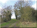
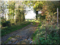
Footpath to Payne's Hill
The path turns off Broad Road by Darrow Green.
Image: © Evelyn Simak
Taken: 7 Nov 2010
0.20 miles
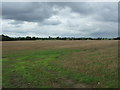
6
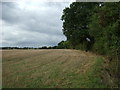
Stubble field and hedgerow
West of Broad Road.
Image: © JThomas
Taken: 12 Oct 2016
0.20 miles
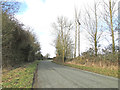
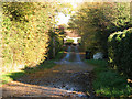
7
Track to Pied Bridge Farm
The track turns off Broad Road by Darrow Green and serves as a public footpath.
Image: © Evelyn Simak
Taken: 7 Nov 2010
0.21 miles