IMAGES TAKEN NEAR TO
Wenhaston Lane, HALESWORTH, IP19 9NH
Introduction
This page details the photographs taken nearby to Wenhaston Lane, IP19 9NH by members of the Geograph project.
The Geograph project started in 2005 with the aim of publishing, organising and preserving representative images for every square kilometre of Great Britain, Ireland and the Isle of Man.

There are currently over 7.5m images from over14,400 individuals and you can help contribute to the project by visiting https://www.geograph.org.uk
Image Map
Images are licensed for reuse under creativecommons.org/licenses/by-sa/2.0
Notes
- Clicking on the map will re-center to the selected point.
- The higher the marker number, the further away the image location is from the centre of the postcode.
Image Listing (7 Images Found)
Images are licensed for reuse under creativecommons.org/licenses/by-sa/2.0
Image
Details
Distance
1
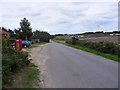
Wenhaston Lane & Heathside Postbox
Looking towards the A12
Postbox No.IP19 5518
Image: © Geographer
Taken: 23 Aug 2010
0.04 miles
2
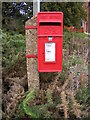
Heathside Postbox
On Wenhaston Lane
Postbox No.IP19 5518
Image: © Geographer
Taken: 23 Aug 2010
0.04 miles
3
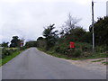
Wenhaston Lane & Heathside Postbox
Looking towards Blackheath
Postbox No.IP19 5518
Image: © Geographer
Taken: 23 Aug 2010
0.04 miles
4
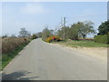
Wenhaston Road
Wenhaston Road looking west near to Blythburgh, Suffolk.
Image: © Keith Evans
Taken: 9 Apr 2015
0.05 miles
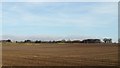
5
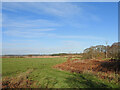
The Southwold railway line ran across this pasture
The line would have emerged from where the trees on the right now stand and across the pasture and disappeared where the bracken can be seen on the extreme left. The 4 mile mile-post was located in the field at the grid reference given for the 'subject's location', TM 44095 74903
Image: © Adrian S Pye
Taken: 19 Jan 2023
0.19 miles
6
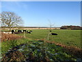
The Southwold railway line ran across this pasture
The line would have emerged from where the trees on the right now stand and across the pasture and disappeared on the extreme left close to the small tin hut seen behind the tree. The 4 mile mile-post was located in the field at the grid reference given for the 'subject's location', TM 44095 74903
Image: © Adrian S Pye
Taken: 19 Jan 2023
0.19 miles