IMAGES TAKEN NEAR TO
Shepherds Cottage, HALESWORTH, IP19 9NE
Introduction
This page details the photographs taken nearby to Shepherds Cottage, IP19 9NE by members of the Geograph project.
The Geograph project started in 2005 with the aim of publishing, organising and preserving representative images for every square kilometre of Great Britain, Ireland and the Isle of Man.

There are currently over 7.5m images from over14,400 individuals and you can help contribute to the project by visiting https://www.geograph.org.uk
Image Map
Images are licensed for reuse under creativecommons.org/licenses/by-sa/2.0
Notes
- Clicking on the map will re-center to the selected point.
- The higher the marker number, the further away the image location is from the centre of the postcode.
Image Listing (4 Images Found)
Images are licensed for reuse under creativecommons.org/licenses/by-sa/2.0
Image
Details
Distance
1
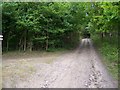
Byway
Looking west along byway, with cottage entrance to the left
Image: © Claire Haystead
Taken: 12 May 2007
0.03 miles
2
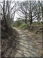
Sandlings Walk
Part of the Sandlings Walk near to Blythburgh, Suffolk.
Image: © Keith Evans
Taken: 9 Apr 2015
0.04 miles
3
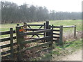
Gates
Gates and footpath junction near to Blythburgh, Suffolk.
Image: © Keith Evans
Taken: 9 Apr 2015
0.04 miles
4
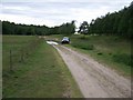
Byway leading to Walberswick
A view looking back west along the Byway that leads eastwards to Walberswick, Suffolk, after heavy rainfall. These rugged routes are best left to Land Rovers and not more conventional cars such as the Dodge as seen here!
Image: © Trevor Alder
Taken: 12 May 2007
0.05 miles