IMAGES TAKEN NEAR TO
Blythburgh, HALESWORTH, IP19 9NB
Introduction
This page details the photographs taken nearby to IP19 9NB by members of the Geograph project.
The Geograph project started in 2005 with the aim of publishing, organising and preserving representative images for every square kilometre of Great Britain, Ireland and the Isle of Man.

There are currently over 7.5m images from over14,400 individuals and you can help contribute to the project by visiting https://www.geograph.org.uk
Image Map
Images are licensed for reuse under creativecommons.org/licenses/by-sa/2.0
Notes
- Clicking on the map will re-center to the selected point.
- The higher the marker number, the further away the image location is from the centre of the postcode.
Image Listing (4 Images Found)
Images are licensed for reuse under creativecommons.org/licenses/by-sa/2.0
Image
Details
Distance
1
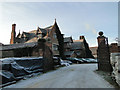
Westwood Lodge, Walberswick
Situated on the heathland and on the edge of a Nature Reserve.
Image: © Adrian S Pye
Taken: 26 Dec 2010
0.02 miles
2
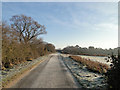
Road from Westwood Lodge
...with Walberswick marshes on the right and Old Covert in the distance.
Image: © Adrian S Pye
Taken: 26 Dec 2010
0.17 miles
3
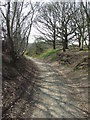
Sandlings Walk
Part of the Sandlings Walk near to Blythburgh, Suffolk.
Image: © Keith Evans
Taken: 9 Apr 2015
0.22 miles
4
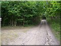
Byway
Looking west along byway, with cottage entrance to the left
Image: © Claire Haystead
Taken: 12 May 2007
0.24 miles