IMAGES TAKEN NEAR TO
Dunwich Road, HALESWORTH, IP19 9LY
Introduction
This page details the photographs taken nearby to Dunwich Road, IP19 9LY by members of the Geograph project.
The Geograph project started in 2005 with the aim of publishing, organising and preserving representative images for every square kilometre of Great Britain, Ireland and the Isle of Man.

There are currently over 7.5m images from over14,400 individuals and you can help contribute to the project by visiting https://www.geograph.org.uk
Image Map
Images are licensed for reuse under creativecommons.org/licenses/by-sa/2.0
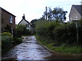
Notes
- Clicking on the map will re-center to the selected point.
- The higher the marker number, the further away the image location is from the centre of the postcode.
Image Listing (43 Images Found)
Images are licensed for reuse under creativecommons.org/licenses/by-sa/2.0
Image
Details
Distance
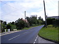
4
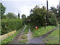
Lodge Lane Bridleway to Tinker's Walks
Off the B1125 Dunwich Road
Image: © Geographer
Taken: 27 Aug 2011
0.08 miles

6
Lodge lane Bridleway to Deadman's Covert & Tinker's Walks
Off Dunwich Lane
Image: © Geographer
Taken: 13 Aug 2011
0.09 miles
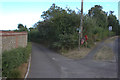
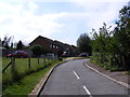
7
Bridleway to the A12 London Road
Off the B1125 Dunwich Road
Image: © Geographer
Taken: 27 Aug 2011
0.09 miles
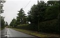
8
Dunwich Lane, Blythburgh
At the junction with Highfield
Image: © Geographer
Taken: 13 Aug 2011
0.10 miles
10
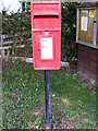
Highfields Postbox
On Highfield at the junction with Dunwich Lane
Postbox No.IP19 8171
Image: © Geographer
Taken: 13 Aug 2011
0.12 miles