IMAGES TAKEN NEAR TO
Thorington, HALESWORTH, IP19 9JF
Introduction
This page details the photographs taken nearby to IP19 9JF by members of the Geograph project.
The Geograph project started in 2005 with the aim of publishing, organising and preserving representative images for every square kilometre of Great Britain, Ireland and the Isle of Man.

There are currently over 7.5m images from over14,400 individuals and you can help contribute to the project by visiting https://www.geograph.org.uk
Image Map
Images are licensed for reuse under creativecommons.org/licenses/by-sa/2.0
Notes
- Clicking on the map will re-center to the selected point.
- The higher the marker number, the further away the image location is from the centre of the postcode.
Image Listing (108 Images Found)
Images are licensed for reuse under creativecommons.org/licenses/by-sa/2.0
Image
Details
Distance
1
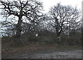
Entrance to Church Farm Nature Reserve
Off Thorington Road
http://www.wildlifetrusts.org/reserves/church-farm
http://live.data.wt.precedenthost.co.uk/sites/live.data.wt.precedenthost.co.uk/files/Church%20Farm%20trail%20map.jpg
Image: © Geographer
Taken: 6 Jan 2014
0.08 miles
2
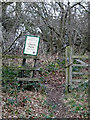
Entrance to Church Farm Nature Reserve
Off Thorington Road
http://www.wildlifetrusts.org/reserves/church-farm
http://live.data.wt.precedenthost.co.uk/sites/live.data.wt.precedenthost.co.uk/files/Church%20Farm%20trail%20map.jpg
(Close up)
Image: © Geographer
Taken: 6 Jan 2014
0.08 miles
3
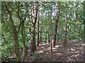
Wood in Church Farm Nature Reserve, Thorington
Church Farm is a Suffolk Wildlife Trust Nature Reserve. It has a combination of flower rich marshland, grassland areas that support an abundance of insects and copses of wet and dry woodland. http://www.wildlifetrusts.org/reserves/church-farm
Image: © Roger Jones
Taken: 13 Jun 2014
0.10 miles
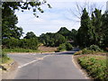
4
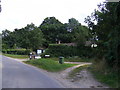
Thorington Road,Thorington
At the junction with Walnut Tree Farm
Image: © Geographer
Taken: 20 Aug 2012
0.11 miles
5
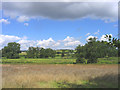
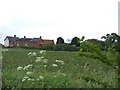
Meadows near Bramfield, Suffolk
Traditional flood meadows north of Thorington Road.
Image: © John Winfield
Taken: 25 Aug 2005
0.15 miles
6
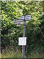
Roadsign on Thorington Road at Thorington Corner
Image: © Geographer
Taken: 14 Aug 2012
0.15 miles
8
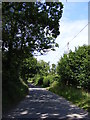
Bartholomew's Lane
Near the junction with Thorington Road
Image: © Geographer
Taken: 14 Aug 2012
0.15 miles
9
Laundry Farm
Looking directly East from the track leading to Walnut Tree Farm
Image: © Claire Haystead
Taken: 12 May 2007
0.17 miles
10
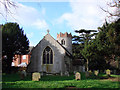
Thorington St Peter?s church
This poor little Norman round-tower church is almost unable to breathe. It is surrounded by trees and suffering from damp. On the Norman tower there is shallow arcading around the middle stage, with loopholes interspersed and lovely round-arched windows. The brickwork forming the octagonal ‘crown’ is a Tudor addition. The tower arch at the west of the nave is restored. The nave roof is of arch-braced construction, with angels at each principal. The octagonal font bowl is typical of the 13th century with arcading similar to that on the tower. The base is 200 years younger. The piscina is from the 14th century and has flush tracery decoration. Some of the benches are quite interesting. There are two parish chests, both of the 17th century, and the Royal Arms are those of George II.
Image: © Adrian S Pye
Taken: 6 Feb 2008
0.21 miles