IMAGES TAKEN NEAR TO
Bramfield, HALESWORTH, IP19 9JD
Introduction
This page details the photographs taken nearby to IP19 9JD by members of the Geograph project.
The Geograph project started in 2005 with the aim of publishing, organising and preserving representative images for every square kilometre of Great Britain, Ireland and the Isle of Man.

There are currently over 7.5m images from over14,400 individuals and you can help contribute to the project by visiting https://www.geograph.org.uk
Image Map
Images are licensed for reuse under creativecommons.org/licenses/by-sa/2.0
Notes
- Clicking on the map will re-center to the selected point.
- The higher the marker number, the further away the image location is from the centre of the postcode.
Image Listing (13 Images Found)
Images are licensed for reuse under creativecommons.org/licenses/by-sa/2.0
Image
Details
Distance
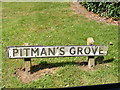
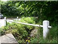
3

Pitman's Grove sign
On Pitman's Grove at the junction with Thorington Road
Image: © Geographer
Taken: 14 Aug 2012
0.04 miles
4
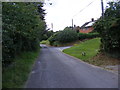
Pitman's Grove, Bramfield
At the junction with Thorington Road.
Image: © Geographer
Taken: 14 Aug 2012
0.04 miles
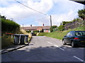
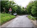
5
Pitman's Grove, Bramfield
At the junction with Pitman's Grove
Image: © Geographer
Taken: 14 Aug 2012
0.05 miles
6
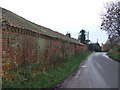
Farm Building Next To Road
Farm building of Hill Farm next to Thorington Road, Bramfield, Suffolk.
Image: © Keith Evans
Taken: 23 Nov 2015
0.09 miles
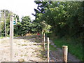
9
Water filled ditch
Water filled ditch running adjacent to Thorington Road, opposite entrance to public footpath.
Image: © Claire Haystead
Taken: 12 May 2007
0.12 miles
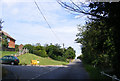
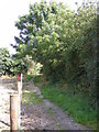
10
View west down Thorington Road
Looking west down Thorington Road leading into the village of Bramfield. The road sign warns of the village primary school which is further up the lane on the left hand side.
Image: © Trevor Alder
Taken: 12 May 2007
0.12 miles