IMAGES TAKEN NEAR TO
Wenhaston, HALESWORTH, IP19 9EN
Introduction
This page details the photographs taken nearby to IP19 9EN by members of the Geograph project.
The Geograph project started in 2005 with the aim of publishing, organising and preserving representative images for every square kilometre of Great Britain, Ireland and the Isle of Man.

There are currently over 7.5m images from over14,400 individuals and you can help contribute to the project by visiting https://www.geograph.org.uk
Image Map
Images are licensed for reuse under creativecommons.org/licenses/by-sa/2.0
Notes
- Clicking on the map will re-center to the selected point.
- The higher the marker number, the further away the image location is from the centre of the postcode.
Image Listing (8 Images Found)
Images are licensed for reuse under creativecommons.org/licenses/by-sa/2.0
Image
Details
Distance
1
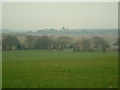
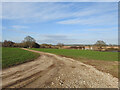
Fields and marshland surrounding Laurel Farm
Taken from the lane leading down to Laurel Farm, also visible in the distance is Blythburgh Church
Image: © Andrew Farrow
Taken: 6 Feb 2005
0.04 miles
2
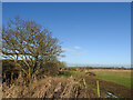
The railway line ran the other side of the posts
There was a footpath across the line at this point designated #24
Image: © Adrian S Pye
Taken: 20 Jan 2023
0.06 miles
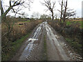
3
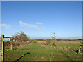
The footpath #25 crosses the railway
The footpath here continues ahead but the railway line used to cross here, right to left on its way to Halesworth past Beaumur Laurel Farm.
Image: © Adrian S Pye
Taken: 20 Jan 2023
0.07 miles
4
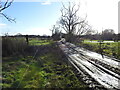
Looking back towards Southwold and bridge #10
The former railway track-bed has been utilised for use by tractors.
Image: © Adrian S Pye
Taken: 20 Jan 2023
0.08 miles
5
Beside the former railway line
The Southwold Railway line passed to the right and continued along this track and passed to the right (north) of Laurel Farm house seen in the trees.
Image: © Adrian S Pye
Taken: 19 Jan 2023
0.08 miles
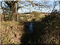
6
The site of the former railway bridge #10
Known as Young's Bridge just south of Beaumur Laurel Farm, it crosses a confluence of drainage channels south of the River Blyth. A wooden structure, it spanned 40 feet (12 metres) supported on two concrete abutments.
No trace of the original bridge remains, as it was blown up by the Home Guard in WWII while practising their demolition skills.
Image: © Adrian S Pye
Taken: 26 Jan 2023
0.10 miles
7
The former Southwold railway line passing over a culvert
The drainage channel is bridged by a culvert
Image: © Adrian S Pye
Taken: 20 Jan 2023
0.15 miles
8
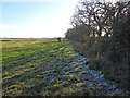
Looking back towards the farm
There is a drainage dyke hidden in the hedgerow. On the left the green grass and flatland of Blythburgh marshes.
Image: © Adrian S Pye
Taken: 20 Jan 2023
0.17 miles