IMAGES TAKEN NEAR TO
Wenhaston, HALESWORTH, IP19 9EL
Introduction
This page details the photographs taken nearby to IP19 9EL by members of the Geograph project.
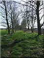
The Geograph project started in 2005 with the aim of publishing, organising and preserving representative images for every square kilometre of Great Britain, Ireland and the Isle of Man.

There are currently over 7.5m images from over14,400 individuals and you can help contribute to the project by visiting https://www.geograph.org.uk
Image Map
Images are licensed for reuse under creativecommons.org/licenses/by-sa/2.0
Notes
- Clicking on the map will re-center to the selected point.
- The higher the marker number, the further away the image location is from the centre of the postcode.
Image Listing (24 Images Found)
Images are licensed for reuse under creativecommons.org/licenses/by-sa/2.0
Image
Details
Distance
1
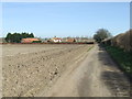
Low Farm
Track leading to Low Farm near Wenhaston, Suffolk.
Image: © Keith Evans
Taken: 12 Mar 2015
0.01 miles
3
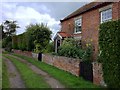
Low Farm
Low Farm, on the public footpath between Wenhaston and Bulcamp.
Image: © Hugh Craddock
Taken: 20 Jul 2012
0.05 miles
4
The former course of the Southwold Railway line
Looking back towards Blythburgh and Southwold this avenue of trees line the original railway track-bed close to Marsh Cottage
Image: © Adrian S Pye
Taken: 26 Jan 2023
0.08 miles
5
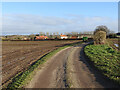
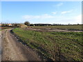
Route Of The Southwold Railway
Looking south east along the former route of the Southwold to Halesworth railway near to Wenhaston, Suffolk. For info on the railway see http://en.wikipedia.org/wiki/Southwold_Railway
Image: © Keith Evans
Taken: 12 Mar 2015
0.08 miles
6
The line approaches Marsh Cottage
The line is still in an avenue of trees, having past Low Farm and approaching Marsh Cottage, the white house on the left.
Image: © Adrian S Pye
Taken: 20 Jan 2023
0.08 miles
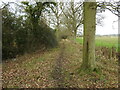
7
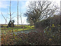
Peering over a hedge blocking the former railway line
The hedge seems to have been reclaimed as part of the garden since the closure of the railway although a footpath does circumvent the obstacle it is very muddy in wet weather
Image: © Adrian S Pye
Taken: 19 Jan 2023
0.08 miles
8
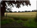
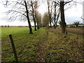
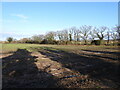
Footpath from Low Farm to Laurel Farm
Cultivated cross-field footpath from Low Farm to Laurel Farm.
Image: © Hugh Craddock
Taken: 20 Jul 2012
0.09 miles
9
The Southwold Railway line overgrown by trees
The line remains partially hidden by the trees and hedgerow until well past Low Farm which can be seen extreme left of the picture
Image: © Adrian S Pye
Taken: 20 Jan 2023
0.11 miles
10
The course of the former railway is apparent
Despite some intrusions by the hedgerow the former track-bed is clear to see
Image: © Adrian S Pye
Taken: 28 Jan 2023
0.12 miles