IMAGES TAKEN NEAR TO
Lower Common, HALESWORTH, IP19 8QU
Introduction
This page details the photographs taken nearby to Lower Common, IP19 8QU by members of the Geograph project.
The Geograph project started in 2005 with the aim of publishing, organising and preserving representative images for every square kilometre of Great Britain, Ireland and the Isle of Man.

There are currently over 7.5m images from over14,400 individuals and you can help contribute to the project by visiting https://www.geograph.org.uk
Image Map
Images are licensed for reuse under creativecommons.org/licenses/by-sa/2.0
Notes
- Clicking on the map will re-center to the selected point.
- The higher the marker number, the further away the image location is from the centre of the postcode.
Image Listing (19 Images Found)
Images are licensed for reuse under creativecommons.org/licenses/by-sa/2.0
Image
Details
Distance
1

A close up of a dragon
This is a cropped view of the dragon featured on the roof of Belle Grove Farm, Westhall, Suffolk. back > http://www.geograph.org.uk/photo/2021607
Image: © Adrian S Pye
Taken: 19 Aug 2010
0.01 miles
2

A Dragon on the roof
What would you do with a Dragon other than put it on your roof? Belle Grove Farm. Westhall, Suffolk. Closer view > http://www.geograph.org.uk/photo/2029201
Image: © Adrian S Pye
Taken: 19 Aug 2010
0.02 miles
3

Watch Dragon
This ornamental dragon is on the entrance gate to Belle Grove Farm, Westhall, Suffolk. On the roof of the house is its mother. http://www.geograph.org.uk/photo/2021607
Image: © Adrian S Pye
Taken: 19 Aug 2010
0.03 miles
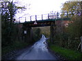
4
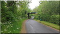
Railway Bridge at Lower Common
Near Belle Grove Farm
Image: © Geographer
Taken: 17 Oct 2006
0.04 miles
5
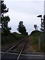
Railway Line to Brampton at Westhall Crossing
Looking towards Brampton
Image: © Geographer
Taken: 24 Jun 2013
0.05 miles
6

Railway bridge
The bridge is between Brampton to Halesworth. Viewed from the west. It carries the Lowestoft to Ipswich line.
Image: © Adrian S Pye
Taken: 19 Aug 2010
0.05 miles
7

Bench mark on a Railway bridge
The cut mark is beneath the bridge at the eastern end of the north wall. It is eroded and roughly 40 cm from ground level. For more information on this and other bench marks visit the bench mark database > http://www.bench-marks.org.uk/bm35252
Image: © Adrian S Pye
Taken: 19 Aug 2010
0.05 miles
8
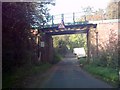
Westhall Road Bridge Identification sign
On Westhall Road
Bridge No. 468 ESK
Image: © Geographer
Taken: 23 Nov 2010
0.05 miles
9
Railway Bridge on Westhall Road
Bridge No. 468 ESK
Image: © Geographer
Taken: 23 Nov 2010
0.05 miles