IMAGES TAKEN NEAR TO
The Street, HALESWORTH, IP19 8PH
Introduction
This page details the photographs taken nearby to The Street, IP19 8PH by members of the Geograph project.
The Geograph project started in 2005 with the aim of publishing, organising and preserving representative images for every square kilometre of Great Britain, Ireland and the Isle of Man.

There are currently over 7.5m images from over14,400 individuals and you can help contribute to the project by visiting https://www.geograph.org.uk
Image Map
Images are licensed for reuse under creativecommons.org/licenses/by-sa/2.0
Notes
- Clicking on the map will re-center to the selected point.
- The higher the marker number, the further away the image location is from the centre of the postcode.
Image Listing (203 Images Found)
Images are licensed for reuse under creativecommons.org/licenses/by-sa/2.0
Image
Details
Distance
1
Bridge over the stream in Holton village centre
Image: © Basher Eyre
Taken: 10 Aug 2010
0.01 miles
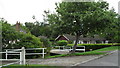
2
Blyford Lane, Holton
At the junction with the B1124 The Street
Image: © Geographer
Taken: 24 Nov 2011
0.01 miles
4
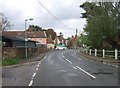
Beccles Road (B1124), Holton
Looking south.
Image: © JThomas
Taken: 13 Oct 2016
0.02 miles
7
Approaching the junction of the B1124 with Bungay Road
Image: © Basher Eyre
Taken: 10 Aug 2010
0.03 miles
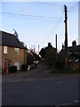
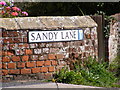
8
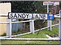
Sandy Lane sign
At the junction with the B1124 The Street
Image: © Geographer
Taken: 24 Nov 2011
0.03 miles
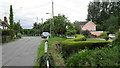
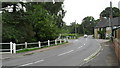
10
Sandy Lane, Holton
Looking towards the junction with the B1124 The Street
Image: © Geographer
Taken: 24 Nov 2011
0.03 miles