IMAGES TAKEN NEAR TO
Sotherton, HALESWORTH, IP19 8NP
Introduction
This page details the photographs taken nearby to IP19 8NP by members of the Geograph project.
The Geograph project started in 2005 with the aim of publishing, organising and preserving representative images for every square kilometre of Great Britain, Ireland and the Isle of Man.

There are currently over 7.5m images from over14,400 individuals and you can help contribute to the project by visiting https://www.geograph.org.uk
Image Map
Images are licensed for reuse under creativecommons.org/licenses/by-sa/2.0
Notes
- Clicking on the map will re-center to the selected point.
- The higher the marker number, the further away the image location is from the centre of the postcode.
Image Listing (9 Images Found)
Images are licensed for reuse under creativecommons.org/licenses/by-sa/2.0
Image
Details
Distance
1
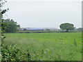
Farm buildings in the drizzle
A large complex of farm buildings can be seen above the hedgerow at Westhall
Image: © Adrian S Pye
Taken: 10 Jun 2010
0.07 miles
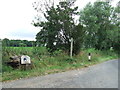
2
Footpath to Church Farm & entrance to Low Farm
Off the B1124 Halesworth Road
Image: © Geographer
Taken: 10 Jun 2013
0.13 miles
3
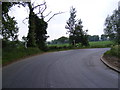
B1124 Halesworth Road, Sotherton
At the entrance to Low Farm
Image: © Geographer
Taken: 11 Jun 2013
0.13 miles
4
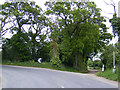
B1124 Halesworth Road & footpath to Church Farm
At the entrance to Low Farm
Image: © Geographer
Taken: 10 Jun 2013
0.13 miles
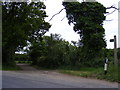
5
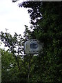
Low Farm sign
At the entrance to Low Farm off the B1124 Halesworth Road
Image: © Geographer
Taken: 10 Jun 2013
0.13 miles
6
Footpath And Farm Entrance
Footpath and farm entrance for Sotherton Low Farm near to Westhall, Suffolk.
Image: © Keith Evans
Taken: 26 Jul 2016
0.15 miles
7

Grazing, Sotherton Low Farm
Off Halesworth Road (B1124).
Image: © JThomas
Taken: 13 Oct 2016
0.20 miles
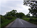
8

Halesworth Road (B1124)
Looking south west.
Image: © JThomas
Taken: 13 Oct 2016
0.22 miles
9
Entering Sotherton on the B1124 Halesworth Road
Image: © Geographer
Taken: 11 Jun 2013
0.24 miles