IMAGES TAKEN NEAR TO
London Road, HALESWORTH, IP19 8LS
Introduction
This page details the photographs taken nearby to London Road, IP19 8LS by members of the Geograph project.
The Geograph project started in 2005 with the aim of publishing, organising and preserving representative images for every square kilometre of Great Britain, Ireland and the Isle of Man.

There are currently over 7.5m images from over14,400 individuals and you can help contribute to the project by visiting https://www.geograph.org.uk
Image Map
Images are licensed for reuse under creativecommons.org/licenses/by-sa/2.0
Notes
- Clicking on the map will re-center to the selected point.
- The higher the marker number, the further away the image location is from the centre of the postcode.
Image Listing (630 Images Found)
Images are licensed for reuse under creativecommons.org/licenses/by-sa/2.0
Image
Details
Distance
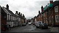
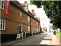
2
Scaffolding on a house near the junction of London Road and Steeple End
Image: © Basher Eyre
Taken: 10 Aug 2010
0.01 miles
4
Chippy at the junction of Swan Lane and London Road
Image: © Basher Eyre
Taken: 10 Aug 2010
0.02 miles
5
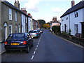
London Road, Halesworth
Looking towards St. Mary's Church.
Road No.U1114
Image: © Geographer
Taken: 27 Oct 2008
0.03 miles
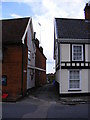
6
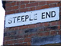
Steeple End sign
At the junction with London Road
Image: © Geographer
Taken: 23 Feb 2012
0.03 miles
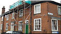
7
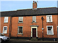
The first police station in Halesworth
This house was used as a police station in the early 1840s while the one in Quay street was being completed. Despite it being a short-term solution a cell was built beneath the front room with the ventilation bars still evident beneath the window.
The house itself was originally an early 18th century with an interior timber frame encased in an outer shell of brick and tile.
This is the earliest of five identified police stations in Halesworth, the others are listed below
Quay Street Image] 1846 to 1865
The Thoroughfare Image] 1865 to 1891
London Road Image] 1891 to 1970
Bungay Road Image] 1970 to present
An earlier police station is believed to have existed in Chediston street but its exact whereabouts has not been positively identified.
Image: © Adrian S Pye
Taken: 15 Feb 2023
0.03 miles
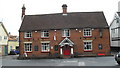
9
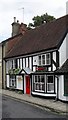
Former almshouses, Halesworth
The row of almshouses seen at left dates from the late 17th century - constructed with money left in the will of William Cary (d. 1686), who wanted to provide a home for a dozen poor single men and women. According to Cary's will the inhabitants were prohibited from smoking, but renovations to the property revealed a cache of smoking implements hidden in a wall cavity. The almshouses are currently home to a Charity shop and an antiques shop. An art gallery is located on the upper floor. The Halesworth and District Museum (it has displays on the witchcraft trials here in 1645, when 4 residents of Halesworth were hung) has moved from here to the former Halesworth railway station building.
Halesworth was granted market town status in 1222 and is a town rich in heritage and history dating back to the Middle Ages. It reached the peak of its prosperity when the River Blyth, on which it sits, was made navigable in 1756, greatly increasing the town's trade particularly for the maltsters and brewers. Halesworth boasts the largest green in the UK, consisting of 43 acres of grazing land that is part of the Blyth Valley Environmentally Sensitive Area, and is a haven for wildlife.
Image: © Evelyn Simak
Taken: 9 Jul 2011
0.04 miles
10
Swan Lane footpath to the A144 Saxons Way & Pound Close
At the junction with London Road
Halesworth footpath no.3
Image: © Geographer
Taken: 6 Jul 2011
0.04 miles