1
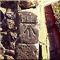
Cut Mark Halesworth St Mary's Church
Cut Mark Halesworth St Mary's Church, tower buttress SE angle.
Image: © Cud05
Taken: 17 Mar 2016
0.01 miles
2
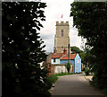
August in Steeple End
Image: © Basher Eyre
Taken: 10 Aug 2010
0.01 miles
3
Church Farm Lane, Halesworth
Looking towards the St.Edmund King & Martyr Catholic Church
Road No.U2715
Image: © Geographer
Taken: 27 Oct 2008
0.01 miles
4
Bench mark on Halesworth St Mary's church
The cut mark is on the south-west buttress of the tower approximately 60cm from ground level facing south-west. For more information on this and other bench marks visit the bench mark database > http://www.bench-marks.org.uk/bm31074
Image: © Adrian S Pye
Taken: 23 Aug 2010
0.01 miles
5
Cottages by St Mary's church, Halesworth
Halesworth was granted market town status in 1222 and is a town rich in heritage and history dating back to the Middle Ages. It reached the peak of its prosperity when the River Blyth, on which it sits, was made navigable in 1756, greatly increasing the town's trade particularly for the maltsters and brewers. Halesworth boasts the largest green in the UK, consisting of 43 acres of grazing land that is part of the Blyth Valley Environmentally Sensitive Area, and is a haven for wildlife.
Image: © Evelyn Simak
Taken: 9 Jul 2011
0.01 miles
6
Lamppost by the churchyard
Image: © Basher Eyre
Taken: 10 Aug 2010
0.02 miles
7
St Mary's church in Halesworth
Viewed from Church Farm Lane. For another view and information on this church go to http://www.geograph.org.uk/photo/2093826.
Image: © Evelyn Simak
Taken: 9 Jul 2011
0.02 miles
8
St Mary's church in Halesworth
Viewed from Church Farm Lane. For another view and information on this church go to http://www.geograph.org.uk/photo/2093826.
Image: © Evelyn Simak
Taken: 9 Jul 2011
0.02 miles
9
Former almshouses, Halesworth
The row of almshouses seen at left dates from the late 17th century - constructed with money left in the will of William Cary (d. 1686), who wanted to provide a home for a dozen poor single men and women. According to Cary's will the inhabitants were prohibited from smoking, but renovations to the property revealed a cache of smoking implements hidden in a wall cavity. The almshouses are currently home to a Charity shop and an antiques shop. An art gallery is located on the upper floor. The Halesworth and District Museum (it has displays on the witchcraft trials here in 1645, when 4 residents of Halesworth were hung) has moved from here to the former Halesworth railway station building.
Halesworth was granted market town status in 1222 and is a town rich in heritage and history dating back to the Middle Ages. It reached the peak of its prosperity when the River Blyth, on which it sits, was made navigable in 1756, greatly increasing the town's trade particularly for the maltsters and brewers. Halesworth boasts the largest green in the UK, consisting of 43 acres of grazing land that is part of the Blyth Valley Environmentally Sensitive Area, and is a haven for wildlife.
Image: © Evelyn Simak
Taken: 9 Jul 2011
0.02 miles
10
St Mary's church in Halesworth - view west
For an exterior view and information on this church go to http://www.geograph.org.uk/photo/2093826.
Image: © Evelyn Simak
Taken: 9 Jul 2011
0.02 miles


