IMAGES TAKEN NEAR TO
London Road, HALESWORTH, IP19 8LH
Introduction
This page details the photographs taken nearby to London Road, IP19 8LH by members of the Geograph project.
The Geograph project started in 2005 with the aim of publishing, organising and preserving representative images for every square kilometre of Great Britain, Ireland and the Isle of Man.

There are currently over 7.5m images from over14,400 individuals and you can help contribute to the project by visiting https://www.geograph.org.uk
Image Map
Images are licensed for reuse under creativecommons.org/licenses/by-sa/2.0
Notes
- Clicking on the map will re-center to the selected point.
- The higher the marker number, the further away the image location is from the centre of the postcode.
Image Listing (691 Images Found)
Images are licensed for reuse under creativecommons.org/licenses/by-sa/2.0
Image
Details
Distance
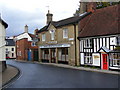
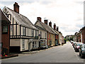
1
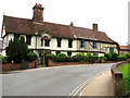
Period houses in London Road, Halesworth
Halesworth was granted market town status in 1222 and is a town rich in heritage and history dating back to the Middle Ages. It reached the peak of its prosperity when the River Blyth, on which it sits, was made navigable in 1756, greatly increasing the town's trade particularly for the maltsters and brewers. Halesworth boasts the largest green in the UK, consisting of 43 acres of grazing land that is part of the Blyth Valley Environmentally Sensitive Area, and is a haven for wildlife.
Image: © Evelyn Simak
Taken: 9 Jul 2011
0.01 miles
2
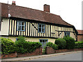
Timber-framed house in London Road, Halesworth
Halesworth was granted market town status in 1222 and is a town rich in heritage and history dating back to the Middle Ages. It reached the peak of its prosperity when the River Blyth, on which it sits, was made navigable in 1756, greatly increasing the town's trade particularly for the maltsters and brewers. Halesworth boasts the largest green in the UK, consisting of 43 acres of grazing land that is part of the Blyth Valley Environmentally Sensitive Area, and is a haven for wildlife.
Image: © Evelyn Simak
Taken: 9 Jul 2011
0.01 miles
3
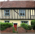
Timber-framed house in London Road, Halesworth (detail)
See > http://www.geograph.org.uk/photo/2498496 for a full view.
Halesworth was granted market town status in 1222 and is a town rich in heritage and history dating back to the Middle Ages. It reached the peak of its prosperity when the River Blyth, on which it sits, was made navigable in 1756, greatly increasing the town's trade particularly for the maltsters and brewers. Halesworth boasts the largest green in the UK, consisting of 43 acres of grazing land that is part of the Blyth Valley Environmentally Sensitive Area, and is a haven for wildlife.
Image: © Evelyn Simak
Taken: 9 Jul 2011
0.01 miles
4
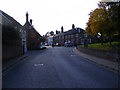
London Road, Halesworth
Near the junction with Steeple End
Road No.U1114
Image: © Geographer
Taken: 27 Oct 2008
0.01 miles

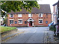
6
The Old Police Station
On The Thoroughfare
Image: © Geographer
Taken: 30 Oct 2008
0.02 miles
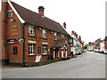
7
The White Swan Public House
In London Road taken from Steeple End
Image: © Geographer
Taken: 27 Oct 2008
0.02 miles
8
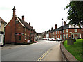
London Road past The White Swan public house, Halesworth
Halesworth was granted market town status in 1222 and is a town rich in heritage and history dating back to the Middle Ages. It reached the peak of its prosperity when the River Blyth, on which it sits, was made navigable in 1756, greatly increasing the town's trade particularly for the maltsters and brewers. Halesworth boasts the largest green in the UK, consisting of 43 acres of grazing land that is part of the Blyth Valley Environmentally Sensitive Area, and is a haven for wildlife.
Image: © Evelyn Simak
Taken: 9 Jul 2011
0.02 miles
9
The White Swan public house in London Road, Halesworth
Halesworth was granted market town status in 1222 and is a town rich in heritage and history dating back to the Middle Ages. It reached the peak of its prosperity when the River Blyth, on which it sits, was made navigable in 1756, greatly increasing the town's trade particularly for the maltsters and brewers. Halesworth boasts the largest green in the UK, consisting of 43 acres of grazing land that is part of the Blyth Valley Environmentally Sensitive Area, and is a haven for wildlife.
Image: © Evelyn Simak
Taken: 9 Jul 2011
0.02 miles
10
Shops and cottages in London Road, Halesworth
Halesworth was granted market town status in 1222 and is a town rich in heritage and history dating back to the Middle Ages. It reached the peak of its prosperity when the River Blyth, on which it sits, was made navigable in 1756, greatly increasing the town's trade particularly for the maltsters and brewers. Halesworth boasts the largest green in the UK, consisting of 43 acres of grazing land that is part of the Blyth Valley Environmentally Sensitive Area, and is a haven for wildlife.
Image: © Evelyn Simak
Taken: 9 Jul 2011
0.02 miles