IMAGES TAKEN NEAR TO
Hillside Way, HALESWORTH, IP19 8JN
Introduction
This page details the photographs taken nearby to Hillside Way, IP19 8JN by members of the Geograph project.
The Geograph project started in 2005 with the aim of publishing, organising and preserving representative images for every square kilometre of Great Britain, Ireland and the Isle of Man.

There are currently over 7.5m images from over14,400 individuals and you can help contribute to the project by visiting https://www.geograph.org.uk
Image Map
Images are licensed for reuse under creativecommons.org/licenses/by-sa/2.0
Notes
- Clicking on the map will re-center to the selected point.
- The higher the marker number, the further away the image location is from the centre of the postcode.
Image Listing (127 Images Found)
Images are licensed for reuse under creativecommons.org/licenses/by-sa/2.0
Image
Details
Distance
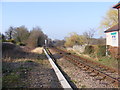
1
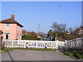
Old Station Road Level Crossing
Now only open for Pedestrians
Image: © Geographer
Taken: 15 Mar 2012
0.04 miles
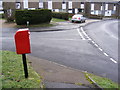
2
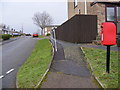
Chichester Road & Chichester Road Postbox
At the junction with Uplands Way
Postbox No. IP19 5510
Image: © Geographer
Taken: 22 Dec 2010
0.07 miles
3
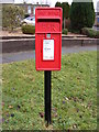
Chichester Road Postbox
On Chichester Road at the junction with Uplands Way
Postbox No. IP19 5510
Image: © Geographer
Taken: 22 Dec 2010
0.07 miles
4
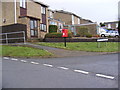
Chichester Road Postbox
On Chichester Road at the junction with Uplands Way
Postbox No. IP19 5510
Image: © Geographer
Taken: 22 Dec 2010
0.07 miles
5
Chichester Road Postbox
On Chichester Road at the junction with Uplands Way
Postbox No.IP19 5510
Image: © Geographer
Taken: 22 Dec 2010
0.07 miles
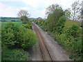
7
Railway Line
Looking towards the A144 Stone Street at Old Station Road Level Crossing
Image: © Geographer
Taken: 15 Mar 2012
0.09 miles
8
Next stop Brampton
Railway line taken from the bridge in Stone Street
Image: © Adrian S Pye
Taken: 14 May 2010
0.09 miles
9
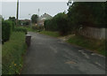
Serpentine wall in Old Station Road, Halesworth
The wall divides what is described as a children's playground and the dwelling house in Old Station Road.
Image: © Adrian S Pye
Taken: 4 May 2023
0.13 miles
10
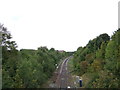
Railway towards Lowestoft
Looking north west from the Bridge on Norwich Road (A144).
Image: © JThomas
Taken: 13 Oct 2016
0.13 miles