IMAGES TAKEN NEAR TO
Norwich Road, HALESWORTH, IP19 8HJ
Introduction
This page details the photographs taken nearby to Norwich Road, IP19 8HJ by members of the Geograph project.
The Geograph project started in 2005 with the aim of publishing, organising and preserving representative images for every square kilometre of Great Britain, Ireland and the Isle of Man.

There are currently over 7.5m images from over14,400 individuals and you can help contribute to the project by visiting https://www.geograph.org.uk
Image Map
Images are licensed for reuse under creativecommons.org/licenses/by-sa/2.0
Notes
- Clicking on the map will re-center to the selected point.
- The higher the marker number, the further away the image location is from the centre of the postcode.
Image Listing (525 Images Found)
Images are licensed for reuse under creativecommons.org/licenses/by-sa/2.0
Image
Details
Distance
1
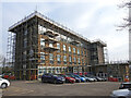
Suffolk Police, Halesworth Division police station
This police station was opened on 29th May 1970 by Sir Robert Gooch. It replaced the former police station in London Road Image
It is currently undergoing external refurbishment.
Earlier police stations in Halesworth can be seen here:
1846 - 1865 Image
1865 - 1891 Image
1891 - 1970 Image
Image: © Adrian S Pye
Taken: 13 Feb 2023
0.02 miles
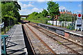
2
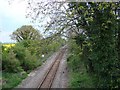
Halesworth next stop
The railway line towards Halesworth taken from the bridge in Stone Street
Image: © Adrian S Pye
Taken: 15 May 2010
0.02 miles
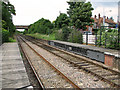
3
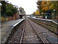
Halesworth Railway Station
Looking down the line towards Brampton off Station Road
Image: © Geographer
Taken: 5 Nov 2008
0.02 miles
4
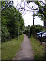
Footpath to Station Road
Near to Halesworth Police Station
Halesworth footpath no.20
Image: © Geographer
Taken: 3 Aug 2010
0.02 miles
7
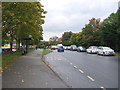
Bus stop and shelter on Norwich Road (A144)
Looking south west.
Image: © JThomas
Taken: 13 Oct 2016
0.02 miles
8
Halesworth railway station - the movable platforms
The contraption incorporated into the platform seen at right is a unique movable platform which could be opened in order to allow traffic to pass here along the Bungay Road. See > http://www.geograph.org.uk/photo/772572. Although trains still pass here the station building has since been closed and currently houses the Halesworth Museum.
Image: © Evelyn Simak
Taken: 9 Jul 2011
0.03 miles
9
Halesworth Portable Platforms
These are moveable platforms from the days before the level crossing was taken out. Beccles is further up but Brampton is the next stop.
Image: © Ashley Dace
Taken: 21 May 2010
0.04 miles
10

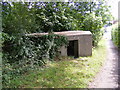
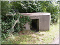
WW2 Pillbox on footpath alongside railway line
The footpath runs from Halesworth rail station & passes this WW2 pillbox which was probably built to protect the station.
Image: © Helen Steed
Taken: 30 Jun 2012
0.04 miles