IMAGES TAKEN NEAR TO
Quay Street, HALESWORTH, IP19 8ET
Introduction
This page details the photographs taken nearby to Quay Street, IP19 8ET by members of the Geograph project.
The Geograph project started in 2005 with the aim of publishing, organising and preserving representative images for every square kilometre of Great Britain, Ireland and the Isle of Man.

There are currently over 7.5m images from over14,400 individuals and you can help contribute to the project by visiting https://www.geograph.org.uk
Image Map
Images are licensed for reuse under creativecommons.org/licenses/by-sa/2.0
Notes
- Clicking on the map will re-center to the selected point.
- The higher the marker number, the further away the image location is from the centre of the postcode.
Image Listing (789 Images Found)
Images are licensed for reuse under creativecommons.org/licenses/by-sa/2.0
Image
Details
Distance
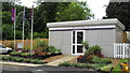
1
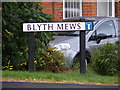
Blyth Mews sign
On Blyth Mews at the junction with the B1123 Quay Street
Image: © Geographer
Taken: 30 Aug 2012
0.01 miles
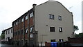
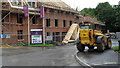
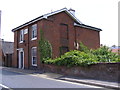
2
Older houses next to the new build in Quay Street
Image: © Basher Eyre
Taken: 10 Aug 2010
0.01 miles
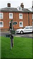
5
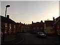
Blyth Mews, Halesworth
At the junction with the B1123 Quay Street
Image: © Geographer
Taken: 9 Dec 2013
0.01 miles
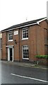
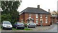
6
Former Police Station
On the B1123 Quay Street
Image: © Geographer
Taken: 11 Jun 2013
0.01 miles
7
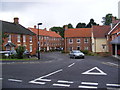
Blyth Mews, Halesworth
At the junction with the B1123 Quay Street
Road No,U1328
Image: © Geographer
Taken: 30 Aug 2012
0.02 miles