IMAGES TAKEN NEAR TO
Market Place, HALESWORTH, IP19 8BB
Introduction
This page details the photographs taken nearby to Market Place, IP19 8BB by members of the Geograph project.
The Geograph project started in 2005 with the aim of publishing, organising and preserving representative images for every square kilometre of Great Britain, Ireland and the Isle of Man.

There are currently over 7.5m images from over14,400 individuals and you can help contribute to the project by visiting https://www.geograph.org.uk
Image Map
Images are licensed for reuse under creativecommons.org/licenses/by-sa/2.0
Notes
- Clicking on the map will re-center to the selected point.
- The higher the marker number, the further away the image location is from the centre of the postcode.
Image Listing (779 Images Found)
Images are licensed for reuse under creativecommons.org/licenses/by-sa/2.0
Image
Details
Distance
1
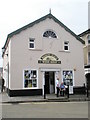
Antiques shop opposite the parish church
Image: © Basher Eyre
Taken: 10 Aug 2010
0.00 miles
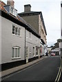
2
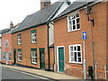
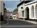
View along Chediston Street, Halesworth
Halesworth was granted market town status in 1222 and is a town rich in heritage and history dating back to the Middle Ages. It reached the peak of its prosperity when the River Blyth, on which it sits, was made navigable in 1756, greatly increasing the town's trade particularly for the maltsters and brewers. Halesworth boasts the largest green in the UK, consisting of 43 acres of grazing land that is part of the Blyth Valley Environmentally Sensitive Area, and is a haven for wildlife.
Image: © Evelyn Simak
Taken: 9 Jul 2011
0.00 miles
3
Shops in Chediston Street, Halesworth
Halesworth was granted market town status in 1222 and is a town rich in heritage and history dating back to the Middle Ages. It reached the peak of its prosperity when the River Blyth, on which it sits, was made navigable in 1756, greatly increasing the town's trade particularly for the maltsters and brewers. Halesworth boasts the largest green in the UK, consisting of 43 acres of grazing land that is part of the Blyth Valley Environmentally Sensitive Area, and is a haven for wildlife.
Image: © Evelyn Simak
Taken: 9 Jul 2011
0.00 miles
4
St Mary, Halesworth: looking from the churchyard towards Thoroughfare
Image: © Basher Eyre
Taken: 10 Aug 2010
0.01 miles
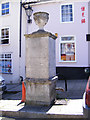
6
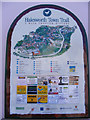
Halesworth Town Trail Sign
On Market Square
Image: © Geographer
Taken: 23 Jun 2009
0.01 miles
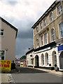
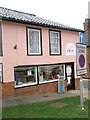
7
Wine shop in Chediston Street
..and in a former chapel, it looks like. What would my old nan have said?
Image: © Basher Eyre
Taken: 10 Aug 2010
0.01 miles
8
Double yellow lines in Chediston Street
Image: © Basher Eyre
Taken: 10 Aug 2010
0.01 miles