IMAGES TAKEN NEAR TO
Silverleys Green, HALESWORTH, IP19 0QJ
Introduction
This page details the photographs taken nearby to Silverleys Green, IP19 0QJ by members of the Geograph project.
The Geograph project started in 2005 with the aim of publishing, organising and preserving representative images for every square kilometre of Great Britain, Ireland and the Isle of Man.

There are currently over 7.5m images from over14,400 individuals and you can help contribute to the project by visiting https://www.geograph.org.uk
Image Map
Images are licensed for reuse under creativecommons.org/licenses/by-sa/2.0
Notes
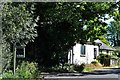
- Clicking on the map will re-center to the selected point.
- The higher the marker number, the further away the image location is from the centre of the postcode.
Image Listing (21 Images Found)
Images are licensed for reuse under creativecommons.org/licenses/by-sa/2.0
Image
Details
Distance
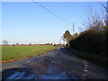
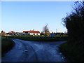
1
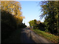
Approaching Silverley's Green road junction
Image: © Geographer
Taken: 30 Nov 2011
0.02 miles
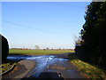
6
Road to North Green
At Silverley's Green
Image: © Geographer
Taken: 30 Nov 2011
0.05 miles
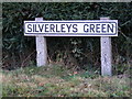
8
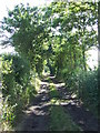
Toggs Lane
This track follows the course of a Roman Road near to Silverley Green, Suffolk.
Image: © Keith Evans
Taken: 12 Sep 2013
0.06 miles
9
Poplar Farm on Silverley's Green
West of Cratfield
Image: © Adrian S Pye
Taken: 28 Nov 2010
0.09 miles
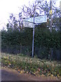
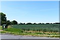
10
North Green road junction
At the junction with Spong Lane
Image: © Geographer
Taken: 30 Nov 2011
0.18 miles