IMAGES TAKEN NEAR TO
Huntingfield, HALESWORTH, IP19 0DB
Introduction
This page details the photographs taken nearby to IP19 0DB by members of the Geograph project.
The Geograph project started in 2005 with the aim of publishing, organising and preserving representative images for every square kilometre of Great Britain, Ireland and the Isle of Man.

There are currently over 7.5m images from over14,400 individuals and you can help contribute to the project by visiting https://www.geograph.org.uk
Image Map
Images are licensed for reuse under creativecommons.org/licenses/by-sa/2.0
Notes
- Clicking on the map will re-center to the selected point.
- The higher the marker number, the further away the image location is from the centre of the postcode.
Image Listing (28 Images Found)
Images are licensed for reuse under creativecommons.org/licenses/by-sa/2.0
Image
Details
Distance
1
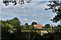
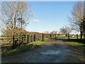
Cratfield: Looking towards Dunnetts Farmhouse
Image: © Michael Garlick
Taken: 29 Jul 2020
0.01 miles
2
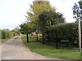
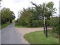
Footpath to Cratfield Road & Entrance to Dunnett's Farm
Off Heveningham Road
Image: © Geographer
Taken: 17 Oct 2011
0.17 miles
3
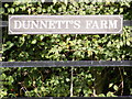
Dunnett's Farm sign
Off Heveningham Road
Image: © Geographer
Taken: 17 Oct 2011
0.17 miles
4
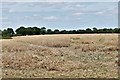
Ubbeston: 'Field peas' dried ready for harvesting for animal feed
Image: © Michael Garlick
Taken: 29 Jul 2020
0.17 miles
6
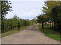
Heveningham Road & the footpath to Cratfield Road
Image: © Geographer
Taken: 17 Oct 2011
0.18 miles
7
Footpath to Cratfield Road & Entrance to Dunnett's Farm
Off Heveningham Road
Image: © Geographer
Taken: 17 Oct 2011
0.18 miles
10
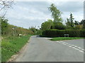
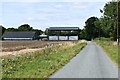
Road Junction
Road junction near to Cratfield, Suffolk.
Image: © Keith Evans
Taken: 10 Apr 2014
0.21 miles