IMAGES TAKEN NEAR TO
The Street, SOUTHWOLD, IP18 6UN
Introduction
This page details the photographs taken nearby to The Street, IP18 6UN by members of the Geograph project.
The Geograph project started in 2005 with the aim of publishing, organising and preserving representative images for every square kilometre of Great Britain, Ireland and the Isle of Man.

There are currently over 7.5m images from over14,400 individuals and you can help contribute to the project by visiting https://www.geograph.org.uk
Image Map
Images are licensed for reuse under creativecommons.org/licenses/by-sa/2.0
Notes
- Clicking on the map will re-center to the selected point.
- The higher the marker number, the further away the image location is from the centre of the postcode.
Image Listing (168 Images Found)
Images are licensed for reuse under creativecommons.org/licenses/by-sa/2.0
Image
Details
Distance
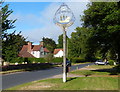
6
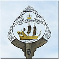
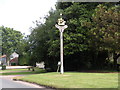
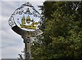
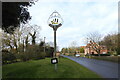
Walberswick village sign
This sign was stolen in 1984 and another slightly smaller made as a replacement. Mr and Mrs Newstead had bought the sign at a garage sale in London in the mid 1990s, without knowing it had been stolen. It was only when on holiday that they saw a road-sign to the village that they became aware that Walberswick was actually a place. They returned the sign to the village and it has been re-erected opposite Walberswick church.
The sign depicts the Walberswick Frigate. It was built on the old quay at the bottom of Stocks Lane for Cromwell's Navy and named "Basing". It was launched in 1654, its length was 80 feet with a beam of 24 feet 6 inches and a draught of 12 feet and carried 22 guns. In 1660, and the restoration of the monarchy, it was renamed "H.M.S. Guernsey" and eventually decommissioned from the Royal Navy in 1693. https://www.geograph.org.uk/photo/6761149
Image: © Adrian S Pye
Taken: 23 Feb 2021
0.02 miles
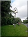
7
Walberswick village sign
This sign was stolen in 1984 and another slightly smaller made as a replacement. Mr and Mrs Newstead had bought the sign at a garage sale in London in the mid 1990s, without knowing it had been stolen. It was only when on holiday that they saw a road-sign to the village that they became aware that Walberswick was actually a place. They returned the sign to the village and it has been re-erected opposite Walberswick church.
The sign depicts the Walberswick Frigate. It was built on the old quay at the bottom of Stocks Lane for Cromwell's Navy and named "Basing". It was launched in 1654, its length was 80 feet with a beam of 24 feet 6 inches and a draught of 12 feet and carried 22 guns. In 1660, and the restoration of the monarchy, it was renamed "H.M.S. Guernsey" and eventually decommissioned from the Royal Navy in 1693. https://www.geograph.org.uk/photo/6761145
Image: © Adrian S Pye
Taken: 23 Feb 2021
0.02 miles
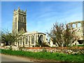
8
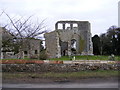
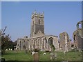
Walberswick Old Church remains
Off the B1387 The Street
Image: © Geographer
Taken: 16 Feb 2009
0.02 miles