IMAGES TAKEN NEAR TO
Stradbroke Road, SOUTHWOLD, IP18 6LL
Introduction
This page details the photographs taken nearby to Stradbroke Road, IP18 6LL by members of the Geograph project.
The Geograph project started in 2005 with the aim of publishing, organising and preserving representative images for every square kilometre of Great Britain, Ireland and the Isle of Man.

There are currently over 7.5m images from over14,400 individuals and you can help contribute to the project by visiting https://www.geograph.org.uk
Image Map
Images are licensed for reuse under creativecommons.org/licenses/by-sa/2.0
Notes
- Clicking on the map will re-center to the selected point.
- The higher the marker number, the further away the image location is from the centre of the postcode.
Image Listing (1084 Images Found)
Images are licensed for reuse under creativecommons.org/licenses/by-sa/2.0
Image
Details
Distance
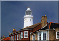
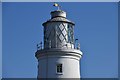
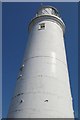
2
Southwold lighthouse.
Set inland from sea front and surrounded by houses.
Image: © Steve Fareham
Taken: 1 Jun 2007
0.01 miles
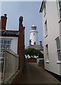
3
Southwold lighthouse from St James' Green
Image: © Steve Daniels
Taken: 5 Oct 2010
0.01 miles
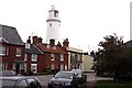
4
Southwold, Suffolk, taken 1962
Another view of the lighthouse in Southwold. The Sole Bay Inn can be seen just to the right of the lighthouse.
Image: © Christine Matthews
Taken: Unknown
0.01 miles
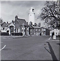
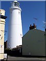
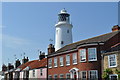
6
Southwold Lighthouse, Suffolk
Southwold Lighthouse is a coastal mark for passing shipping and guides vessels into Southwold Harbour. The lighthouse is situated near the centre of the seaside resort of Southwold, midway between Lowestoft and Orford, the round white tower stands amongst rows of small houses.
Construction of Southwold Lighthouse began in 1887 under the supervision of Sir James Douglass, Engineer in Chief to Trinity House. The lighthouse replaced three local lighthouses which were under threat from severe coastal erosion at Orfordness to the South. While the masonry tower was built a temporary light was shown from a wooden structure which was first lit on 19th February 1889.
The present lighthouse came into operation on 3rd September 1890. The light was originally provided by an Argand burner, this was replaced by a Matthews incandescent oil burner in 1906. A Hood 100mm petroleum vapour burner was installed in 1923 and remained until the station was electrified and demanned in 1938. Two red sectors mark shoals to the north and the Sizewell Bank to the south, the main navigation light is white.
A local Attendant visits the lighthouse regularly to conduct routine maintenance.
http://www.trinityhouse.co.uk/interactive/gallery/southwold.html
Image: © Christine Matthews
Taken: 6 Jul 1995
0.02 miles
7
Southwold Lighthouse
Construction of Southwold Lighthouse began in 1887 under the supervision of Sir James Douglass, Engineer in Chief to Trinity House. The lighthouse replaced three local lighthouses which were under threat from severe coastal erosion at Orfordness to the South. While the masonry tower was built a temporary light was shown from a wooden structure which was first lit on 19th February 1889.
Image: © Maigheach-gheal
Taken: 17 Apr 2008
0.02 miles
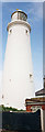
9
Lighthouse
This lighthouse dominates Southwold and can be seen from miles around. It is possible to go on lighthouse tours; suffering from vertigo, I opted to give that a miss!
Image: © Fractal Angel
Taken: 1 Aug 2007
0.02 miles
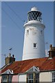
10
Southwold Lighthouse
It was constructed by Trinity House from 1887 and was taken into service in 1890. It replaced three lighthouses which had been condemned due to serious coastal erosion.
Image: © Ashley Dace
Taken: 4 Jul 2011
0.02 miles