IMAGES TAKEN NEAR TO
Barnaby Green, SOUTHWOLD, IP18 6AP
Introduction
This page details the photographs taken nearby to Barnaby Green, IP18 6AP by members of the Geograph project.
The Geograph project started in 2005 with the aim of publishing, organising and preserving representative images for every square kilometre of Great Britain, Ireland and the Isle of Man.

There are currently over 7.5m images from over14,400 individuals and you can help contribute to the project by visiting https://www.geograph.org.uk
Image Map
Images are licensed for reuse under creativecommons.org/licenses/by-sa/2.0
Notes
- Clicking on the map will re-center to the selected point.
- The higher the marker number, the further away the image location is from the centre of the postcode.
Image Listing (694 Images Found)
Images are licensed for reuse under creativecommons.org/licenses/by-sa/2.0
Image
Details
Distance
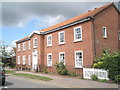
1
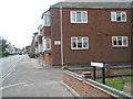
Junction of Crick Court and Station Road
Image: © Basher Eyre
Taken: 8 Aug 2010
0.01 miles
2
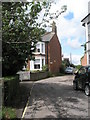
Spinners Lane
Detroit or Scouse variety, I wonder?
Image: © Basher Eyre
Taken: 8 Aug 2010
0.02 miles
6
Footpath sign on the edge of Southwold Common
Image: © Basher Eyre
Taken: 8 Aug 2010
0.03 miles
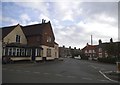
7
Junction of Field Stile Road /Station Road/High Street
Standing on North Green looking towards the King's Head
Image: © John UDEN
Taken: 30 Dec 2008
0.03 miles
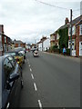
10
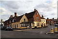
The King's Head, Southwold
Good for watching football, but its beer quality is a notch lower than all the surrounding outlets.
Image: © Bill Boaden
Taken: 29 Aug 2009
0.03 miles