IMAGES TAKEN NEAR TO
Rectory Road, SAXMUNDHAM, IP17 3NR
Introduction
This page details the photographs taken nearby to Rectory Road, IP17 3NR by members of the Geograph project.
The Geograph project started in 2005 with the aim of publishing, organising and preserving representative images for every square kilometre of Great Britain, Ireland and the Isle of Man.

There are currently over 7.5m images from over14,400 individuals and you can help contribute to the project by visiting https://www.geograph.org.uk
Image Map
Images are licensed for reuse under creativecommons.org/licenses/by-sa/2.0
Notes
- Clicking on the map will re-center to the selected point.
- The higher the marker number, the further away the image location is from the centre of the postcode.
Image Listing (115 Images Found)
Images are licensed for reuse under creativecommons.org/licenses/by-sa/2.0
Image
Details
Distance
1
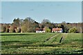
Middleton: Across a field to houses in Back Road
Image: © Michael Garlick
Taken: 25 Feb 2022
0.09 miles
6
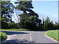
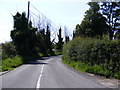
B1125 Leiston Road
At the junction with Rectory Road (U2828)
Image: © Geographer
Taken: 4 Jul 2011
0.15 miles
7
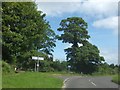
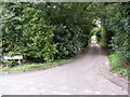
Junction on B1125 for Middleton
The junction is on a bend, with a tall tree dominating the view north
Image: © David Smith
Taken: 17 Jun 2014
0.15 miles
8

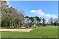
Holy Trinity Church, Middleton: a verdant churchyard
Image: © Basher Eyre
Taken: 9 Aug 2010
0.15 miles
9
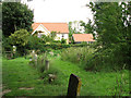
Cottage by the churchyard, Middleton
For a view of the church see > http://www.geograph.org.uk/photo/2555162.
Image: © Evelyn Simak
Taken: 14 Aug 2011
0.15 miles
10
Fletchers Lane, Middleton
At the junction with Back Road
Road No.U2324
Image: © Geographer
Taken: 18 Aug 2010
0.15 miles