IMAGES TAKEN NEAR TO
Bridge Street, SAXMUNDHAM, IP17 2PG
Introduction
This page details the photographs taken nearby to Bridge Street, IP17 2PG by members of the Geograph project.
The Geograph project started in 2005 with the aim of publishing, organising and preserving representative images for every square kilometre of Great Britain, Ireland and the Isle of Man.

There are currently over 7.5m images from over14,400 individuals and you can help contribute to the project by visiting https://www.geograph.org.uk
Image Map
Images are licensed for reuse under creativecommons.org/licenses/by-sa/2.0
Notes
- Clicking on the map will re-center to the selected point.
- The higher the marker number, the further away the image location is from the centre of the postcode.
Image Listing (131 Images Found)
Images are licensed for reuse under creativecommons.org/licenses/by-sa/2.0
Image
Details
Distance
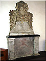
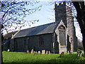
1
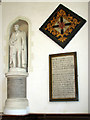
The church of St Mary and St Peter, Kelsale
Memorial and hatchment. For an exterior view of this church see > http://www.geograph.org.uk/photo/2628877. For information about this church go to: http://www.geograph.org.uk/photo/2102290.
Image: © Evelyn Simak
Taken: 1 Oct 2011
0.09 miles
2
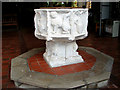
The church of St Mary and St Peter, Kelsale
Medieval font. For an exterior view of this church see > http://www.geograph.org.uk/photo/2628877. For information about this church go to: http://www.geograph.org.uk/photo/2102290.
Image: © Evelyn Simak
Taken: 1 Oct 2011
0.09 miles
3
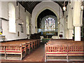
The church of St Mary and St Peter, Kelsale
View east. For an exterior view of this church see > http://www.geograph.org.uk/photo/2628877. For information about this church go to: http://www.geograph.org.uk/photo/2102290.
Image: © Evelyn Simak
Taken: 1 Oct 2011
0.09 miles
4
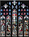
The church of St Mary and St Peter, Kelsale
East window. For an exterior view of this church see > http://www.geograph.org.uk/photo/2628877. For information about this church go to: http://www.geograph.org.uk/photo/2102290.
Image: © Evelyn Simak
Taken: 1 Oct 2011
0.09 miles
5
The church of St Mary and St Peter, Kelsale
Memorial. For an exterior view of this church see > http://www.geograph.org.uk/photo/2628877. For information about this church go to: http://www.geograph.org.uk/photo/2102290.
Image: © Evelyn Simak
Taken: 1 Oct 2011
0.09 miles


9
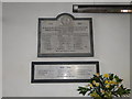
Kelsale with Carlton War Memorials
The names from both parishes are combined on the memorial.
27 names are on the WW1 Memorial and 10 on the WW2 Memorial below.
Their details can be seen here: http://media.geograph.org.uk/files/fe9fc289c3ff0af142b6d3bead98a923/KELSALE_War_Memorial.pdf
Image: © Adrian S Pye
Taken: 20 Apr 2016
0.10 miles
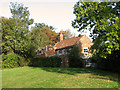
10
St.Mary's Church, Kelsale
Off Church Lane near Denny's Lane
http://www.suffolkchurches.co.uk/kelsale.html
Image: © Geographer
Taken: 21 Apr 2009
0.10 miles