IMAGES TAKEN NEAR TO
Mill Road, SAXMUNDHAM, IP17 2LL
Introduction
This page details the photographs taken nearby to Mill Road, IP17 2LL by members of the Geograph project.
The Geograph project started in 2005 with the aim of publishing, organising and preserving representative images for every square kilometre of Great Britain, Ireland and the Isle of Man.

There are currently over 7.5m images from over14,400 individuals and you can help contribute to the project by visiting https://www.geograph.org.uk
Image Map
Images are licensed for reuse under creativecommons.org/licenses/by-sa/2.0
Notes
- Clicking on the map will re-center to the selected point.
- The higher the marker number, the further away the image location is from the centre of the postcode.
Image Listing (104 Images Found)
Images are licensed for reuse under creativecommons.org/licenses/by-sa/2.0
Image
Details
Distance
1
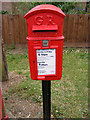
5 Mill Road George V Postbox
On Mill Road at the junction with Mount Pleasant
Postbox No. IP17 4672
Image: © Geographer
Taken: 13 Jul 2009
0.02 miles
2
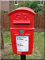
5 Mill Road George V Postbox
On Mill Road at the junction with Mount Pleasant
Postbox No. IP17 4672
(Close up)
Image: © Geographer
Taken: 13 Jul 2009
0.02 miles
4
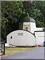
Peasenhall Post Mill
Off Mill Road
(Close up)
Image: © Geographer
Taken: 27 May 2011
0.08 miles
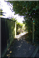
6
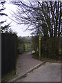
Footpath to the A1120 Hackney Road
Taken at Mount Pleasant
Peasenhall Footpath No.16
Image: © Geographer
Taken: 15 Feb 2011
0.10 miles
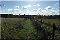
7
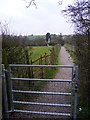
Footpath Gate on footpath to the A1120 Hackney Road
At Mount Pleasant
Peasenhall footpath No.16
Image: © Geographer
Taken: 15 Feb 2011
0.10 miles