IMAGES TAKEN NEAR TO
Brooke Drive, SAXMUNDHAM, IP17 2LG
Introduction
This page details the photographs taken nearby to Brooke Drive, IP17 2LG by members of the Geograph project.
The Geograph project started in 2005 with the aim of publishing, organising and preserving representative images for every square kilometre of Great Britain, Ireland and the Isle of Man.

There are currently over 7.5m images from over14,400 individuals and you can help contribute to the project by visiting https://www.geograph.org.uk
Image Map
Images are licensed for reuse under creativecommons.org/licenses/by-sa/2.0
Notes
- Clicking on the map will re-center to the selected point.
- The higher the marker number, the further away the image location is from the centre of the postcode.
Image Listing (246 Images Found)
Images are licensed for reuse under creativecommons.org/licenses/by-sa/2.0
Image
Details
Distance
1
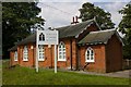
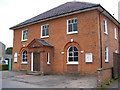
Sibton Nursery School
This looks to be the new use for the building currently marked as a chapel on the OS Map.
Image: © Fractal Angel
Taken: 1 Aug 2007
0.01 miles
2
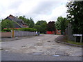
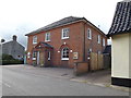
Brooke Drive, Sibton
At the junction with the A1120 Chapel Street
Image: © Geographer
Taken: 19 May 2009
0.03 miles
3
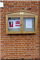
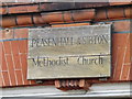
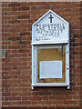
Peasenhall & Sibton Methodist Church Notice Board
(In the Memory of Margaret Abbott 1926-2016)
Off the A1120 Chapel Street
Image: © Geographer
Taken: 12 Jun 2018
0.03 miles
4
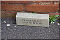
Commemorative Brick at the Peasenhall & Sibton Methodist Church
Off the A1120 Chapel Street
Image: © Geographer
Taken: 12 Jun 2018
0.03 miles
5
Peasenhall & Sibton Methodist Church
Peasenhall Methodist Church was built in 1809 and opened by Dr. Thomas Coke, the pioneer of home missions as well as of the work overseas. The Church celebrated it's bi-centenary in May 2009.
Off Chapel Street
https://eangliamethodist.org.uk/peasenhall
Image: © Geographer
Taken: 27 Aug 2008
0.03 miles
6
Peasenhall & Sibton Methodist Church
Off the A1120 Chapel Street
https://eangliamethodist.org.uk/peasenhall
Image: © Geographer
Taken: 1 Jul 2016
0.03 miles
7
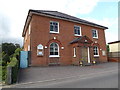
Peasenhall & Sibton Methodist Church
Off the A1120 Chapel Street
https://eangliamethodist.org.uk/peasenhall
Image: © Geographer
Taken: 1 Jul 2016
0.03 miles
8
Peasenhall & Sibton Methodist Church sign
Off the A1120 Chapel Street
https://eangliamethodist.org.uk/peasenhall
Image: © Geographer
Taken: 1 Jul 2016
0.03 miles
9
Peasenhall & Sibton Methodist Church Notice Board
Off the A1120 Chapel Street
https://eangliamethodist.org.uk/peasenhall
Image: © Geographer
Taken: 1 Jul 2016
0.03 miles
10

Brooke Drive, Sibton
At the junction with the A1120 Chapel Street.
Image: © Geographer
Taken: 3 Nov 2017
0.03 miles