IMAGES TAKEN NEAR TO
Hollow Lane, SAXMUNDHAM, IP17 2JZ
Introduction
This page details the photographs taken nearby to Hollow Lane, IP17 2JZ by members of the Geograph project.
The Geograph project started in 2005 with the aim of publishing, organising and preserving representative images for every square kilometre of Great Britain, Ireland and the Isle of Man.

There are currently over 7.5m images from over14,400 individuals and you can help contribute to the project by visiting https://www.geograph.org.uk
Image Map
Images are licensed for reuse under creativecommons.org/licenses/by-sa/2.0
Notes
- Clicking on the map will re-center to the selected point.
- The higher the marker number, the further away the image location is from the centre of the postcode.
Image Listing (32 Images Found)
Images are licensed for reuse under creativecommons.org/licenses/by-sa/2.0
Image
Details
Distance
1
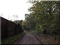
Hollow Lane, Sibton
Looking towards Hollow Lane (New Road)
Image: © Geographer
Taken: 8 Nov 2013
0.02 miles
2
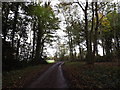
Hollow Lane (New Road), Sibton
Looking towards Hill Farm
Road No.U2607
Image: © Geographer
Taken: 8 Nov 2013
0.04 miles
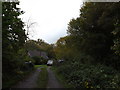
3
Hollow Lane (New Road), Sibton
Road No.U2607
Image: © Geographer
Taken: 20 Mar 2009
0.11 miles
5
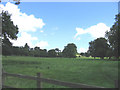
Sibton Park, Sibton, Suffolk
Sibton Park is a Georgian manor house built in 1827, and photograph shows part of the 350 acres of wood and parkland in which it is situated.
Image: © John Winfield
Taken: 23 Aug 2005
0.14 miles
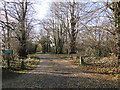
6

The Clock House, in the grounds of Sibton Hall
Taken with the kind permission of the owner.
Image: © Adrian S Pye
Taken: 18 Jan 2011
0.15 miles

8
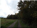
Farm Track near Big Wood & Wood Cottage
Off Hollow Lane (New Road)
Image: © Geographer
Taken: 8 Nov 2013
0.16 miles
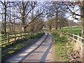
10
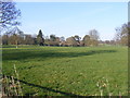
Sibton Park, Sibton
Off Hollow Lane (New Road) (U2607)
Taken from near the bridge
Image: © Geographer
Taken: 20 Mar 2009
0.18 miles