IMAGES TAKEN NEAR TO
Hackney Road, SAXMUNDHAM, IP17 2HR
Introduction
This page details the photographs taken nearby to Hackney Road, IP17 2HR by members of the Geograph project.
The Geograph project started in 2005 with the aim of publishing, organising and preserving representative images for every square kilometre of Great Britain, Ireland and the Isle of Man.

There are currently over 7.5m images from over14,400 individuals and you can help contribute to the project by visiting https://www.geograph.org.uk
Image Map
Images are licensed for reuse under creativecommons.org/licenses/by-sa/2.0
Notes
- Clicking on the map will re-center to the selected point.
- The higher the marker number, the further away the image location is from the centre of the postcode.
Image Listing (300 Images Found)
Images are licensed for reuse under creativecommons.org/licenses/by-sa/2.0
Image
Details
Distance
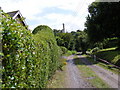
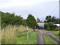
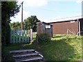
1
Entrance to Oak View
Off the A1120 Hackney Road
Image: © Geographer
Taken: 17 Jul 2011
0.02 miles
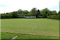
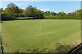
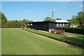
3
Peasenhall Bowling Green
Off the A1120 Hackney Road
Image: © Geographer
Taken: 18 Sep 2008
0.03 miles
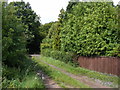
4
Track to Peasenhall Primary School Playing Field
Image: © Geographer
Taken: 17 Jul 2011
0.03 miles
6
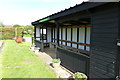
The David Langford Pavilion
At Peasenhall & Sibton Bowling Green
Image: © Geographer
Taken: 4 May 2018
0.04 miles
7
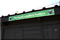
The David Langford Pavilion sign
At Peasenhall & Sibton Bowling Green
Image: © Geographer
Taken: 4 May 2018
0.04 miles
8
The David Langford Pavilion
At Peasenhall & Sibton Bowling Green
Image: © Geographer
Taken: 4 May 2018
0.04 miles
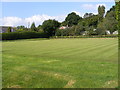
9
Peasenhall Bowls Club
Off the A1120 Hackney Road
Image: © Geographer
Taken: 18 Sep 2008
0.04 miles