IMAGES TAKEN NEAR TO
The Street, SAXMUNDHAM, IP17 2HJ
Introduction
This page details the photographs taken nearby to The Street, IP17 2HJ by members of the Geograph project.
The Geograph project started in 2005 with the aim of publishing, organising and preserving representative images for every square kilometre of Great Britain, Ireland and the Isle of Man.

There are currently over 7.5m images from over14,400 individuals and you can help contribute to the project by visiting https://www.geograph.org.uk
Image Map
Images are licensed for reuse under creativecommons.org/licenses/by-sa/2.0
Notes
- Clicking on the map will re-center to the selected point.
- The higher the marker number, the further away the image location is from the centre of the postcode.
Image Listing (302 Images Found)
Images are licensed for reuse under creativecommons.org/licenses/by-sa/2.0
Image
Details
Distance
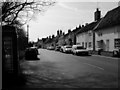
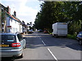
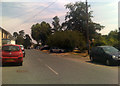
2
Peasenhall, The Street
Former Swan public house and maltings on The Street in Peasenhall, converted to residential properties
Image: © Richard Croft
Taken: 8 Sep 2013
0.02 miles
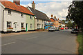
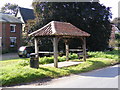
3
The Causeway, Peasenhall
On the A1120 The Street near Peasenhall Telephone Exchange
Image: © Geographer
Taken: 17 Mar 2015
0.02 miles
7

Broadband Fibre Cabinets
At Peasenhall Telephone Exchange off The Causeway on the A1120 The Street
Image: © Geographer
Taken: 17 Mar 2015
0.02 miles
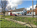
8
Peasenhall Bus Shelter
On the A1120 The Street
Image: © Geographer
Taken: 18 Sep 2008
0.02 miles
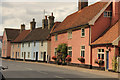
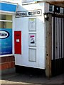
9
A1120 The Street, Peasenhall
Near Peasenhall Village Store & Post Office
Image: © Geographer
Taken: 6 Jul 2018
0.02 miles