IMAGES TAKEN NEAR TO
Snape Road, SAXMUNDHAM, IP17 1RX
Introduction
This page details the photographs taken nearby to Snape Road, IP17 1RX by members of the Geograph project.
The Geograph project started in 2005 with the aim of publishing, organising and preserving representative images for every square kilometre of Great Britain, Ireland and the Isle of Man.

There are currently over 7.5m images from over14,400 individuals and you can help contribute to the project by visiting https://www.geograph.org.uk
Image Map
Images are licensed for reuse under creativecommons.org/licenses/by-sa/2.0
Notes
- Clicking on the map will re-center to the selected point.
- The higher the marker number, the further away the image location is from the centre of the postcode.
Image Listing (29 Images Found)
Images are licensed for reuse under creativecommons.org/licenses/by-sa/2.0
Image
Details
Distance
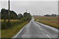
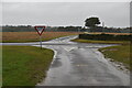
3
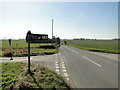
Information sign to Marsh Farm at the Red Lane junction
Image: © Adrian S Pye
Taken: 7 Mar 2011
0.13 miles
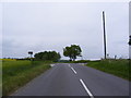
6
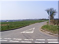
Red Lane, Sternfield
At the crossroads with the C247
Road No.U2319
Image: © Geographer
Taken: 29 Mar 2011
0.15 miles
7
Red Lane, Sternfield
At the junction with the C247
Road No.U2308
Image: © Geographer
Taken: 29 Mar 2011
0.15 miles
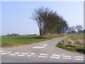
8
Red Lane
At the junction with Sternfield Road
Road No.U2319
Image: © Geographer
Taken: 27 May 2010
0.16 miles
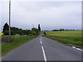
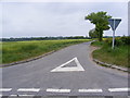
10
Crossroads on the Sternfield Road
At the junction with Red Lane
Road No.C247
To the right is road no.U2308 and the left is U2319
Image: © Geographer
Taken: 27 May 2010
0.16 miles