IMAGES TAKEN NEAR TO
Sandy Lane, SAXMUNDHAM, IP17 1RT
Introduction
This page details the photographs taken nearby to Sandy Lane, IP17 1RT by members of the Geograph project.
The Geograph project started in 2005 with the aim of publishing, organising and preserving representative images for every square kilometre of Great Britain, Ireland and the Isle of Man.

There are currently over 7.5m images from over14,400 individuals and you can help contribute to the project by visiting https://www.geograph.org.uk
Image Map
Images are licensed for reuse under creativecommons.org/licenses/by-sa/2.0
Notes
- Clicking on the map will re-center to the selected point.
- The higher the marker number, the further away the image location is from the centre of the postcode.
Image Listing (112 Images Found)
Images are licensed for reuse under creativecommons.org/licenses/by-sa/2.0
Image
Details
Distance
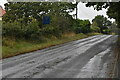
1
Waiting for the school bus at Sternfield
Near Saxmundham on the B1121.
Image: © Oliver Dixon
Taken: 5 Jun 2006
0.07 miles
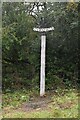
8
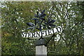
Sternfield village sign
The sign is skilfully made of steel and is based on the leaves and fruit of the horse chestnut tree, which proliferate in the parish.
https://www.geograph.org.uk/photo/6635993
Image: © Adrian S Pye
Taken: 12 Oct 2020
0.12 miles
9
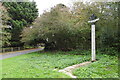
Sternfield village sign
The sign is skilfully made of steel and is based on the leaves and fruit of the horse chestnut tree, which proliferate in the parish.
https://www.geograph.org.uk/photo/6635989
Image: © Adrian S Pye
Taken: 12 Oct 2020
0.12 miles