IMAGES TAKEN NEAR TO
Church Hill, SAXMUNDHAM, IP17 1RS
Introduction
This page details the photographs taken nearby to Church Hill, IP17 1RS by members of the Geograph project.
The Geograph project started in 2005 with the aim of publishing, organising and preserving representative images for every square kilometre of Great Britain, Ireland and the Isle of Man.

There are currently over 7.5m images from over14,400 individuals and you can help contribute to the project by visiting https://www.geograph.org.uk
Image Map
Images are licensed for reuse under creativecommons.org/licenses/by-sa/2.0
Notes
- Clicking on the map will re-center to the selected point.
- The higher the marker number, the further away the image location is from the centre of the postcode.
Image Listing (101 Images Found)
Images are licensed for reuse under creativecommons.org/licenses/by-sa/2.0
Image
Details
Distance
4
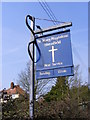
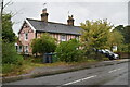
St. Mary Magdalene Church sign, Sternfield
On the B1121 Church Hill
Image: © Geographer
Taken: 29 Mar 2011
0.09 miles
5
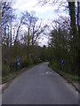
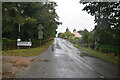
B1121 Church Hill
Looking towards Sternfield at Benhall Bridge
Image: © Geographer
Taken: 10 Apr 2012
0.09 miles
6
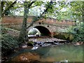
Benhall River Bridge
Benhall river bridge seen from the downstream side of the bridge.
Image: © Adrian S Pye
Taken: 23 Sep 2010
0.09 miles
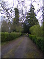
7
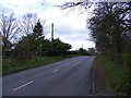
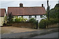
B1121 Church Hill, Sternfield
Looking towards the B1121 Main Road near St.Mary Magdalene Church
Image: © Geographer
Taken: 10 Apr 2012
0.09 miles
8
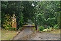
The entrance to St.Mary Magdalene Church, Sternfield
Off the B1121 Church Hill
Image: © Geographer
Taken: 10 Apr 2012
0.10 miles
9
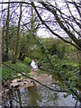
River Fromus at Benhall Bridge
Off the B1121 Church Hill
Image: © Geographer
Taken: 10 Apr 2012
0.10 miles