IMAGES TAKEN NEAR TO
Saxonfields, SAXMUNDHAM, IP17 1QA
Introduction
This page details the photographs taken nearby to Saxonfields, IP17 1QA by members of the Geograph project.
The Geograph project started in 2005 with the aim of publishing, organising and preserving representative images for every square kilometre of Great Britain, Ireland and the Isle of Man.

There are currently over 7.5m images from over14,400 individuals and you can help contribute to the project by visiting https://www.geograph.org.uk
Image Map
Images are licensed for reuse under creativecommons.org/licenses/by-sa/2.0
Notes
- Clicking on the map will re-center to the selected point.
- The higher the marker number, the further away the image location is from the centre of the postcode.
Image Listing (62 Images Found)
Images are licensed for reuse under creativecommons.org/licenses/by-sa/2.0
Image
Details
Distance
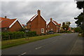
2
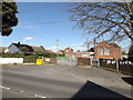
Snape Primary School
Off the B1069 Church Road
Image: © Geographer
Taken: 11 Apr 2015
0.07 miles
3
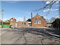
Snape Primary School
Off the B1069 Church Road
Image: © Geographer
Taken: 11 Apr 2015
0.07 miles
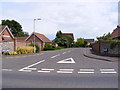
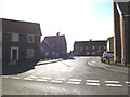
4
B1069 Church Road, Snape
At the junction with Pryor Close
Image: © Geographer
Taken: 11 Apr 2015
0.08 miles
5
Pryor Close, Snape
At the junction with the B1069 Church Road
Image: © Geographer
Taken: 11 Apr 2015
0.08 miles
6
Prior Close, Snape
At the junction with the B1069 Church Road
Image: © Geographer
Taken: 11 Apr 2015
0.08 miles
7
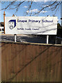
Snape Primary School sign
Off the B1069 Church Road
Image: © Geographer
Taken: 11 Apr 2015
0.08 miles
8

B1069 Church Road, Snape
At Snape Primary School
Image: © Geographer
Taken: 11 Apr 2015
0.08 miles
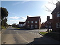
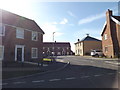
9
Church Road, Snape
On the left, the Pryor Close development, at this time only a few years old.
Image: © Christopher Hilton
Taken: 13 Oct 2017
0.08 miles
10

St.Benedick's Place sign
Off the B1069 Church Road
Image: © Geographer
Taken: 11 Apr 2014
0.09 miles