IMAGES TAKEN NEAR TO
Aldeburgh Road, SAXMUNDHAM, IP17 1PD
Introduction
This page details the photographs taken nearby to Aldeburgh Road, IP17 1PD by members of the Geograph project.
The Geograph project started in 2005 with the aim of publishing, organising and preserving representative images for every square kilometre of Great Britain, Ireland and the Isle of Man.

There are currently over 7.5m images from over14,400 individuals and you can help contribute to the project by visiting https://www.geograph.org.uk
Image Map
Images are licensed for reuse under creativecommons.org/licenses/by-sa/2.0
Notes
- Clicking on the map will re-center to the selected point.
- The higher the marker number, the further away the image location is from the centre of the postcode.
Image Listing (15 Images Found)
Images are licensed for reuse under creativecommons.org/licenses/by-sa/2.0
Image
Details
Distance
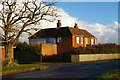
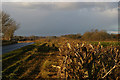
1
Track leading north at Hazlewood Hall Farm
Image: © Christopher Hilton
Taken: 29 Nov 2017
0.03 miles
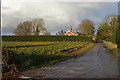
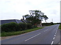
2
The entrance to Hazlewood Hall Farm
Off the A1094 Aldeburgh Road
Image: © Geographer
Taken: 21 Jul 2011
0.06 miles
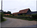
3
The entrance to Hazlewood Hall Farm
Off the A1094 Aldeburgh Road
Image: © Geographer
Taken: 21 Jul 2011
0.06 miles
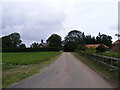
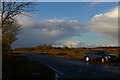
5
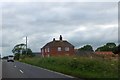
Looking west along the A1094 at Hazlewood Hall
Image: © Christopher Hilton
Taken: 29 Nov 2017
0.06 miles
6
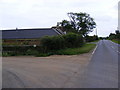
A1094 Aldeburgh Road & entrance to Hazlewood Hall Farm
Looking towards Aldeburgh
Image: © Geographer
Taken: 21 Jul 2011
0.06 miles
7
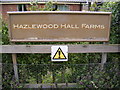
Hazlewood Hall Farm sign
Off the A1094 Aldeburgh Road
Image: © Geographer
Taken: 21 Jul 2011
0.06 miles
9
A1094 Aldeburgh Road
Looking towards Aldeburgh near the entrance to Hazlewood Hall Farm
Image: © Geographer
Taken: 21 Jul 2011
0.08 miles