IMAGES TAKEN NEAR TO
Ayden Way, SAXMUNDHAM, IP17 1HG
Introduction
This page details the photographs taken nearby to Ayden Way, IP17 1HG by members of the Geograph project.
The Geograph project started in 2005 with the aim of publishing, organising and preserving representative images for every square kilometre of Great Britain, Ireland and the Isle of Man.

There are currently over 7.5m images from over14,400 individuals and you can help contribute to the project by visiting https://www.geograph.org.uk
Image Map
Images are licensed for reuse under creativecommons.org/licenses/by-sa/2.0
Notes
- Clicking on the map will re-center to the selected point.
- The higher the marker number, the further away the image location is from the centre of the postcode.
Image Listing (50 Images Found)
Images are licensed for reuse under creativecommons.org/licenses/by-sa/2.0
Image
Details
Distance
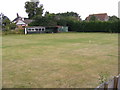
1
Village School
The village school at Benhall Green, Suffolk.
Image: © Keith Evans
Taken: 2 Apr 2015
0.11 miles
2
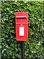
The Green Postbox
On Forge Close
Postbox No. IP17 4686
Image: © Geographer
Taken: 13 Jul 2009
0.11 miles
3
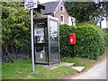
Telephone Box & The Green Postbox
On Forge Close
Postbox No. IP17 4686
Image: © Geographer
Taken: 13 Jul 2009
0.11 miles
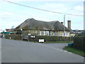
5
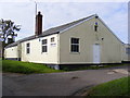
Benhall Club & Village Hall
Off School Lane near Forge Close
Image: © Geographer
Taken: 14 Oct 2008
0.12 miles
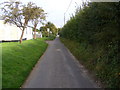
6
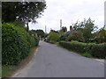
Forge Close, Benhall Green
Near the junction with The Beeches
Image: © Geographer
Taken: 13 Jul 2009
0.13 miles
7
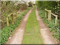
Cattle Grid on entrance to Manor Farm
Benhall footpath no.27
Image: © Geographer
Taken: 4 Apr 2011
0.13 miles
8
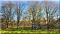
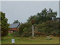
Benhall Green
A group of trees in the middle of this rural community in East Suffolk.
Image: © Jonathan Billinger
Taken: 22 Nov 2021
0.13 miles
9
School Lane, Benhall
Near Benhall Club & Village Hall
Road No.U2311
Image: © Geographer
Taken: 14 Oct 2008
0.13 miles