IMAGES TAKEN NEAR TO
Chantry Road, SAXMUNDHAM, IP17 1DJ
Introduction
This page details the photographs taken nearby to Chantry Road, IP17 1DJ by members of the Geograph project.
The Geograph project started in 2005 with the aim of publishing, organising and preserving representative images for every square kilometre of Great Britain, Ireland and the Isle of Man.

There are currently over 7.5m images from over14,400 individuals and you can help contribute to the project by visiting https://www.geograph.org.uk
Image Map
Images are licensed for reuse under creativecommons.org/licenses/by-sa/2.0
Notes
- Clicking on the map will re-center to the selected point.
- The higher the marker number, the further away the image location is from the centre of the postcode.
Image Listing (681 Images Found)
Images are licensed for reuse under creativecommons.org/licenses/by-sa/2.0
Image
Details
Distance
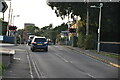
1
![Saxmundham houses [18]](https://s2.geograph.org.uk/geophotos/06/72/88/6728822_7501d8d1_120x120.jpg)
Saxmundham houses [18]
Numbers 14 and 16 Chantry Road are a pair of houses built circa 1840 in brick. Listed, grade II, with details at: https://historicengland.org.uk/listing/the-list/list-entry/1268182
Saxmundham is a small market town about 5 miles from the Sussex coast and some 18 miles north east of Ipswich. The River Fromus, a tributary of the River Alde flows through the town. A market charter was first granted in 1272 and a market is still held every Wednesday. Until 1988 the town was astride the A12 trunk road but is now bypassed.
Image: © Michael Dibb
Taken: 10 Sep 2020
0.01 miles
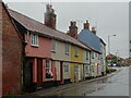
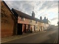
3
![Saxmundham houses [19]](https://s0.geograph.org.uk/geophotos/06/72/88/6728824_e819e405_120x120.jpg)
Saxmundham houses [19]
Chantry Cottages are a row of six cottages built in the early 18th century with later alterations. The ground floor is brick, the first floor is timber farmed and stuccoed. Listed, grade II, with details at: https://historicengland.org.uk/listing/the-list/list-entry/1268181
Saxmundham is a small market town about 5 miles from the Sussex coast and some 18 miles north east of Ipswich. The River Fromus, a tributary of the River Alde flows through the town. A market charter was first granted in 1272 and a market is still held every Wednesday. Until 1988 the town was astride the A12 trunk road but is now bypassed.
Image: © Michael Dibb
Taken: 10 Sep 2020
0.01 miles
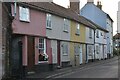
5
Cottages on Chantry Road, Saxmundham
Image: © Christopher Hilton
Taken: 20 Jul 2019
0.01 miles
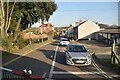
7
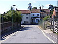
New Cut, Saxmundham
At the junction with Chantry Road
Image: © Geographer
Taken: 30 Jun 2011
0.02 miles