IMAGES TAKEN NEAR TO
Epsom Drive, IPSWICH, IP1 6SS
Introduction
This page details the photographs taken nearby to Epsom Drive, IP1 6SS by members of the Geograph project.
The Geograph project started in 2005 with the aim of publishing, organising and preserving representative images for every square kilometre of Great Britain, Ireland and the Isle of Man.

There are currently over 7.5m images from over14,400 individuals and you can help contribute to the project by visiting https://www.geograph.org.uk
Image Map
Images are licensed for reuse under creativecommons.org/licenses/by-sa/2.0
Notes
- Clicking on the map will re-center to the selected point.
- The higher the marker number, the further away the image location is from the centre of the postcode.
Image Listing (18 Images Found)
Images are licensed for reuse under creativecommons.org/licenses/by-sa/2.0
Image
Details
Distance
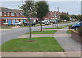
1
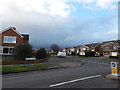
Fircroft Road
The end of Fircroft Road where it meats Defoe Road. See http://www.geograph.org.uk/photo/3853912 for another view.
Image: © Hamish Griffin
Taken: 18 Feb 2014
0.12 miles
2
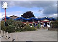
The Man on the Moon Pub, Where on Earth is it ?
Situated in Palmcroft Road, Castle Hill.
Image: © Eric Woodhouse
Taken: 2 Oct 2005
0.12 miles
3
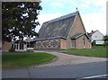
Congregational Church Dryden Road
A stone was dedicated on behalf of the Ipswich Congregational Council, by Alderman S. Charles Grimwade J.P. on 8th October 1955.
Image: © Eric Woodhouse
Taken: 2 Oct 2005
0.12 miles
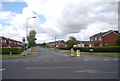
4
Fircroft Road
The end of Fircroft Road where it meats Defoe Road.
Image: © Hamish Griffin
Taken: 18 Feb 2014
0.12 miles
5
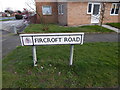
Fircroft Road sign
Fircroft Road sign-the end of Fircroft Road where it meats Defoe Road see http://www.geograph.org.uk/photo/3853912.
Image: © Hamish Griffin
Taken: 18 Feb 2014
0.12 miles
9
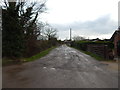
Looking towards Church Farm, Thurleston
Looking towards Church Farm, Thurleston. According to the map, where I am is about where Thurleston church (St Botolph) was (TM154482) http://www.suffolkchurches.co.uk/thurleston.html
Image: © Hamish Griffin
Taken: 18 Feb 2014
0.20 miles
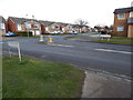
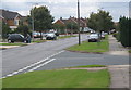
10
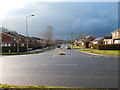
Defoe Road junction Henley Road, Castle Hill
Defoe Road junction Henley Road, Castle Hill.
Image: © Hamish Griffin
Taken: 18 Feb 2014
0.20 miles