IMAGES TAKEN NEAR TO
Carlyle Close, IPSWICH, IP1 6JL
Introduction
This page details the photographs taken nearby to Carlyle Close, IP1 6JL by members of the Geograph project.
The Geograph project started in 2005 with the aim of publishing, organising and preserving representative images for every square kilometre of Great Britain, Ireland and the Isle of Man.

There are currently over 7.5m images from over14,400 individuals and you can help contribute to the project by visiting https://www.geograph.org.uk
Image Map
Images are licensed for reuse under creativecommons.org/licenses/by-sa/2.0
Notes
- Clicking on the map will re-center to the selected point.
- The higher the marker number, the further away the image location is from the centre of the postcode.
Image Listing (23 Images Found)
Images are licensed for reuse under creativecommons.org/licenses/by-sa/2.0
Image
Details
Distance
1
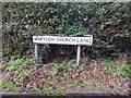
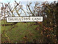
Whitton Church Lane at Thurleston Lane
Whitton Church Lane at Thurleston Lane.
Image: © Hamish Griffin
Taken: 18 Feb 2014
0.02 miles
2
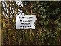
St Mary and St Botolph, Whitton sign
St Mary and St Botolph, Whitton, Ipswich sign. See http://www.geograph.org.uk/photo/61166 for the church. The church is currently at St Mary's Church, Whitton but it is also called St Botolph because of the former church at Thurleston. http://www.suffolkchurches.co.uk/thurleston.html
Image: © Hamish Griffin
Taken: 18 Feb 2014
0.03 miles
3
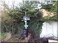
Whitton Park sign at the Whitton Church Lane/Thurleton Lane junction
Whitton Park sign at the Whitton Church Lane/Thurleton Lane junction http://www.geograph.org.uk/photo/3853413.
Image: © Hamish Griffin
Taken: 18 Feb 2014
0.03 miles
4
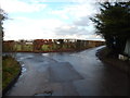
Whitton Church Lane at Thurleston Lane (junction visible)
Whitton Church Lane at Thurleston Lane junction. See http://www.geograph.org.uk/photo/3853413 for the sign.
Image: © Hamish Griffin
Taken: 18 Feb 2014
0.03 miles
5
The start of Thurleston Lane at Whitton Church Lane
The start of Thurleston Lane (or end if you are going the other way) at Whitton Church Lane.
Image: © Hamish Griffin
Taken: 18 Feb 2014
0.03 miles
6
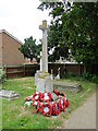
The War Memorial in Whitton churchyard
The Memorial is to nine men lost in WW1 from the villages of Whitton and Thurleston and to the many who lost their lives in WW2.
Image: © Adrian S Pye
Taken: 23 Jun 2015
0.04 miles
7
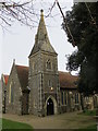
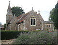
The Church of St Mary at Whitton
Viewed from the south-west.
Image: © Peter Wood
Taken: 22 Feb 2015
0.04 miles
8
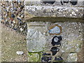
Ordnance Survey Cut Mark
This mark can be found on the wall of St Mary's Church at Whitton.
For more detail see : http://www.bench-marks.org.uk/bm49359
Image: © Peter Wood
Taken: 22 Feb 2015
0.04 miles
9
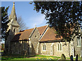
Church of St Mary and St Botolph, Whitton
Image: © Andrew Hill
Taken: 23 Aug 2008
0.04 miles
10
Whitton (cum Thurleston) St Mary?s church
This church was almost entirely rebuilt by the Victorians in the style of the late 13th, early 14th century. The south aisle, tower and lovely broached spire were all constructed from the disused St Botolph’s church at Thurleston, less than a half mile away across the fields. (St. Botolph’s fell into disrepair in 1528 and was eventually used as a barn until 1867.) The rebuilt tower doorway is 13th century, and the single bell is dated 1441. Almost everything inside the church is post-1870, the date of the restoration. The piscina, however, is 13th century and the roof of the chancel is also original. The church owns an Elizabethan chalice but this is held elsewhere for safe keeping. The church is slowly being encroached upon by development, as are many suburban churches today.
Image: © Adrian S Pye
Taken: 14 Mar 2007
0.06 miles