IMAGES TAKEN NEAR TO
Keats Crescent, IPSWICH, IP1 6HS
Introduction
This page details the photographs taken nearby to Keats Crescent, IP1 6HS by members of the Geograph project.
The Geograph project started in 2005 with the aim of publishing, organising and preserving representative images for every square kilometre of Great Britain, Ireland and the Isle of Man.

There are currently over 7.5m images from over14,400 individuals and you can help contribute to the project by visiting https://www.geograph.org.uk
Image Map
Images are licensed for reuse under creativecommons.org/licenses/by-sa/2.0
Notes
- Clicking on the map will re-center to the selected point.
- The higher the marker number, the further away the image location is from the centre of the postcode.
Image Listing (5 Images Found)
Images are licensed for reuse under creativecommons.org/licenses/by-sa/2.0
Image
Details
Distance
1
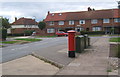
Postbox at the western end of Defoe Road
Approaching the junction with Macaulay Road.
Image: © Andrew Hill
Taken: 23 Aug 2008
0.18 miles
2
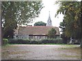
St Mary & St Botolph Church
Situated in the Parish of Whitton, in 1841, the population was 422. Today, it is a little short of 25,000.
Image: © Eric Woodhouse
Taken: 2 Oct 2005
0.18 miles