IMAGES TAKEN NEAR TO
Stony Lane, LEISTON, IP16 4WN
Introduction
This page details the photographs taken nearby to Stony Lane, IP16 4WN by members of the Geograph project.
The Geograph project started in 2005 with the aim of publishing, organising and preserving representative images for every square kilometre of Great Britain, Ireland and the Isle of Man.

There are currently over 7.5m images from over14,400 individuals and you can help contribute to the project by visiting https://www.geograph.org.uk
Image Map
Images are licensed for reuse under creativecommons.org/licenses/by-sa/2.0
Notes
- Clicking on the map will re-center to the selected point.
- The higher the marker number, the further away the image location is from the centre of the postcode.
Image Listing (321 Images Found)
Images are licensed for reuse under creativecommons.org/licenses/by-sa/2.0
Image
Details
Distance
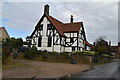
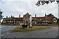
6
Old Homes Road, Thorpeness
At the junction with the B1353 The Haven
http://www.thorpenessdolphin.com/index.php?pid=1
Image: © Geographer
Taken: 27 Jan 2015
0.02 miles
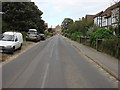
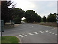
7
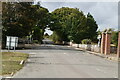
B1353, The Whinlands
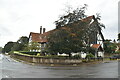
The gated entrance in the distance is that of the Almshouses shown in this image Image
Image: © Oxyman
Taken: 28 Aug 2008
0.02 miles
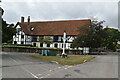
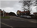
9
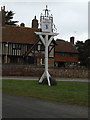
The Dolphin Inn Public House sign
Off Old Homes Road at the junction with the B1353 The Havenhttp://www.thorpenessdolphin.com/index.php?pid=1
Image: © Geographer
Taken: 27 Jan 2015
0.02 miles