IMAGES TAKEN NEAR TO
The Common, LEISTON, IP16 4UW
Introduction
This page details the photographs taken nearby to The Common, IP16 4UW by members of the Geograph project.
The Geograph project started in 2005 with the aim of publishing, organising and preserving representative images for every square kilometre of Great Britain, Ireland and the Isle of Man.

There are currently over 7.5m images from over14,400 individuals and you can help contribute to the project by visiting https://www.geograph.org.uk
Image Map
Images are licensed for reuse under creativecommons.org/licenses/by-sa/2.0
Notes
- Clicking on the map will re-center to the selected point.
- The higher the marker number, the further away the image location is from the centre of the postcode.
Image Listing (32 Images Found)
Images are licensed for reuse under creativecommons.org/licenses/by-sa/2.0
Image
Details
Distance
6
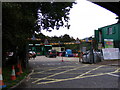
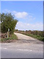
Lover's Lane, Leiston & Lovers Lane Bridleway
Looking towards the Household Waste Centre
Road No.U2822
Leiston Bridleway No.19
Image: © Geographer
Taken: 18 Jul 2011
0.10 miles
9
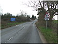
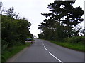
Road Signs
Road signs on minor road near to Leiston, Suffolk.
Image: © Keith Evans
Taken: 5 Mar 2015
0.11 miles
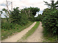
10
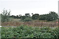
Footpath to Sandy Lane
On Leiston Common off Lover's Lane (U2822)
Leiston footpath no.30
Image: © Geographer
Taken: 26 Apr 2010
0.11 miles