IMAGES TAKEN NEAR TO
Halfway Houses, LEISTON, IP16 4TS
Introduction
This page details the photographs taken nearby to Halfway Houses, IP16 4TS by members of the Geograph project.
The Geograph project started in 2005 with the aim of publishing, organising and preserving representative images for every square kilometre of Great Britain, Ireland and the Isle of Man.

There are currently over 7.5m images from over14,400 individuals and you can help contribute to the project by visiting https://www.geograph.org.uk
Image Map
Images are licensed for reuse under creativecommons.org/licenses/by-sa/2.0
Notes
- Clicking on the map will re-center to the selected point.
- The higher the marker number, the further away the image location is from the centre of the postcode.
Image Listing (21 Images Found)
Images are licensed for reuse under creativecommons.org/licenses/by-sa/2.0
Image
Details
Distance
1
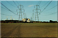
Power lines emerging from Sizewell nuclear power station, Suffolk
– crossing fields of sandy soils.
Image: © Rodney Burton
Taken: 23 May 1991
0.13 miles
2
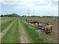
Footpath And Pigs
Footpath and pigs near to Sizewell, Suffolk.
Image: © Keith Evans
Taken: 27 May 2015
0.13 miles
3
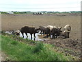
Happy
Pigs happy in the mud near to Sizewell, Suffolk.
Image: © Keith Evans
Taken: 27 May 2015
0.15 miles
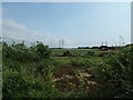
7
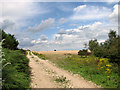
Track into fields by Crown Farm, Leiston
Image: © Evelyn Simak
Taken: 14 Aug 2011
0.16 miles
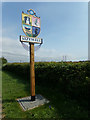
10

Sizewell Village sign on Sizewell Gap
(Close up)
Image: © Geographer
Taken: 14 May 2018
0.17 miles