IMAGES TAKEN NEAR TO
Saxmundham Road, LEISTON, IP16 4TH
Introduction
This page details the photographs taken nearby to Saxmundham Road, IP16 4TH by members of the Geograph project.
The Geograph project started in 2005 with the aim of publishing, organising and preserving representative images for every square kilometre of Great Britain, Ireland and the Isle of Man.

There are currently over 7.5m images from over14,400 individuals and you can help contribute to the project by visiting https://www.geograph.org.uk
Image Map
Images are licensed for reuse under creativecommons.org/licenses/by-sa/2.0
Notes
- Clicking on the map will re-center to the selected point.
- The higher the marker number, the further away the image location is from the centre of the postcode.
Image Listing (14 Images Found)
Images are licensed for reuse under creativecommons.org/licenses/by-sa/2.0
Image
Details
Distance
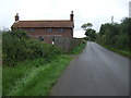
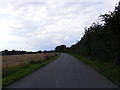
2
Westhouse Cottage
Westhouse Cottage near to Knodishall, Suffolk.
Image: © Keith Evans
Taken: 14 Jun 2016
0.01 miles
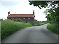
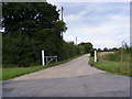
4
Abbey Lane
Looking towards Wheathouse Cottage & Leiston near the Cemex Concrete Plant
Image: © Geographer
Taken: 12 Aug 2010
0.09 miles
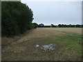
5
Abbey Lane
Looking towards the junction with Hawthorn Road near the Cemex Concrete Plant
Image: © Geographer
Taken: 12 Aug 2010
0.09 miles

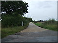
7
Entrance to the Cemex Concrete Plant
Off Abbey Lane
Image: © Geographer
Taken: 12 Aug 2010
0.09 miles
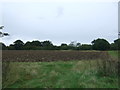
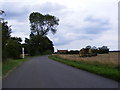
10
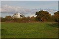
Cement works across the field, near Westhouse Cottage
This works is Cemex's Saxmundham Plant.
Image: © Christopher Hilton
Taken: 6 Nov 2019
0.13 miles