IMAGES TAKEN NEAR TO
Aldringham, LEISTON, IP16 4QT
Introduction
This page details the photographs taken nearby to IP16 4QT by members of the Geograph project.
The Geograph project started in 2005 with the aim of publishing, organising and preserving representative images for every square kilometre of Great Britain, Ireland and the Isle of Man.

There are currently over 7.5m images from over14,400 individuals and you can help contribute to the project by visiting https://www.geograph.org.uk
Image Map
Images are licensed for reuse under creativecommons.org/licenses/by-sa/2.0
Notes
- Clicking on the map will re-center to the selected point.
- The higher the marker number, the further away the image location is from the centre of the postcode.
Image Listing (46 Images Found)
Images are licensed for reuse under creativecommons.org/licenses/by-sa/2.0
Image
Details
Distance
1
Church Lane, Ardringham
Near St Andrew's Church
Image: © Geographer
Taken: 27 Jan 2015
0.02 miles
2
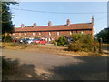
Ogilvie Almshouses, next to Aldringham church
Image: © Christopher Hilton
Taken: 19 Jul 2018
0.03 miles
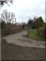
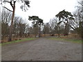
4
Footpath to the B1122 Aldeburgh Road
Off Church Lane next to St.Andrew's Church
Image: © Geographer
Taken: 26 Apr 2010
0.04 miles
5
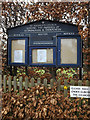
St.Andrew's Church Notice Board
Off Church Lane
Image: © Geographer
Taken: 27 Jan 2015
0.04 miles
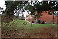
6
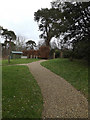
Church path of St.Andrew's Church
Off Church Lane
Image: © Geographer
Taken: 27 Jan 2015
0.05 miles
7
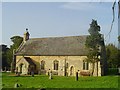
Aldringham (cum Thorpe) St Andrew's church
Some distance from the village up a dusty trackway on the Thorpeness road is where you will find this charming little church. It was completely rebuilt as the painting inside the church will illustrate. It originally had a substantial square tower. Now a small bell turret with a single bell sits above the roof at the west end.
Image: © Adrian S Pye
Taken: 23 Sep 2010
0.05 miles
8
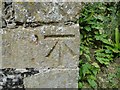
Bench mark on St Andrew's church Aldringham
The cut mark is on the SE buttress of the chancel, facing SE 50cms above ground level. For more information on this and other bench marks visit the bench mark database > http://www.bench-marks.org.uk/bm27442 To view the church > http://www.geograph.org.uk/photo/2079720
Image: © Adrian S Pye
Taken: 23 Sep 2010
0.05 miles
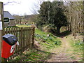
9
Church Lane & Church car park
Near St Andrew's Church
Image: © Geographer
Taken: 27 Jan 2015
0.05 miles
10
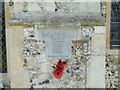
Aldringham WW2 Memorial
The Memorial is on the outside south wall of the nave.
Image: © Adrian S Pye
Taken: 30 Apr 2015
0.05 miles